
Deskewed Me … Or Not
In the first of your articles simplifyingSkew-T diagrams (March 2020), you mention that a reader suggested you simplify them or stop writing about these mystifying charts. Well, I’m the reader who sent that pointed email about the Skew-T chart. I’ve read part one, and it was easy to follow. Thanks.
Part 2 came today. I’ll keep you posted. I want to thank y’all for being so responsive and trying to get these intimidating diagrams to make sense. I was at a meeting a couple of weeks ago with a bunch of pilots, mostly retired military or airline guys, and a CFI pal asked, “Have you ever tried to understand those #$&*ing Skew-T charts?” I told him to read all about them in IFR!
Thanks again! Stay safe. With our Covid-inspired shelter-in-place orders, I might start reading the back issues all over again. I’ll bet there are many nuggets in them that I’ve overlooked.
Eddie Esserman
St. Simons Island, GA
Glad they’re making sense, Eddie, and thanks for letting us know.
I imagine that the Skew-T is a wonderful data source for meteorologists that helps them produce the valuable and ever more sophisticated weather products that we pilots use.
While I understand that knowing how the Skew-T works might be an interesting exercise for the curious, I’m afraid I don’t see that it has any practical use for pilots. I’ll leave Skew-T interpretation to the professional meteorologists, not us amateurs, and instead use one of the more useful products derived from it.
Joe Mazza
Queensbury, NY
Cancel IFR
Terrance Kramer’s article, “Paper Stops,” in March was excellent. It is always good to hear from the folks on the other side of the radio. It helps me understand where I can help the controller, and thereby also help the planes around me. I will strive to cancel IFR in the air to help keep traffic moving.
Bill Fahey
San Antonio, TX
Glad you liked the article, Bill.
In your efficiency of cancelling in the air, be careful not to cancel too early. Pilots have on occasion been busted for cancelling with the runway in sight, but without VMC. The biggest temptation is not waiting to get 500 feet below the clouds. So, be sure you’ve got VFR conditions before you cancel.
Got Paint?
Your February article, “The Power of Paint,” by Luca Bencini-Tibo was fantastic. Maybe I knew all of these details at some point (doubtful…) but we really do take much of this for granted and tend not to notice the differences between runways when using them. This type of article is what makes IFR so useful.
Luca states that “if a runway has a precision approach to one end, but a non-precision approach to the other end, both ends will have precision markings.”
Well KLNS has precision markings at the ILS 8 end, but not at the GPS 26 end. Is KLNS an outlier in this regard or did I misunderstand the point?
Thanks for a great thought producer regardless.
Andrew Doorey
Raleigh/Durham, NC
It appears that Runway 26 is lacking the touchdown zone stripes to make it a “ full” precision.” The other end has non-precision markings and an LPV, not technically a precision approach. Maybe they ran out of paint? Or perhaps the ILS was installed years before the GPS approach? Regardless it is an outlier.
This happens. See Lantana, FL (KLNA), with an LP to Runway 34 and none to the other end. Yet, both ends have non-precision marks. But, go figure, some airports have LPVs to both ends and only visual marks. One such airport’s manager responded with, “Let’s see if the FAA catches it.” The paint used on runways is special and expensive, requiring at least $10,000 just to paint one end. —Luca Bencini-Tibo
Odd Note
When looking for an alternate for a nearby airport, I saw the note on the ILS for KPBG, “RNAV 1-GPS Required.” I understand this to mean 1 NM accuracy for 95% of flight time. Why is this included on an ILS approach procedure?
I assume the RNAV requirement is for the missed approach holding fix, JUTEK. But, I’m curious about the RNAV 1 spec—shouldn’t that be RNP?—and why GPS specifically rather than any other RNP RNAV system?
As an aside, look at the whole missed approach. You’ll need to remember to switch your box from VLOC to GPS in the midst of cleaning up the plane and climbing to 700. Since the DA is 377, this doesn’t leave much time for all that. Hopefully, you’ll have fully briefed the approach to remember to make that change in the event of a missed.
Richard Jacobs
Bedford, MA
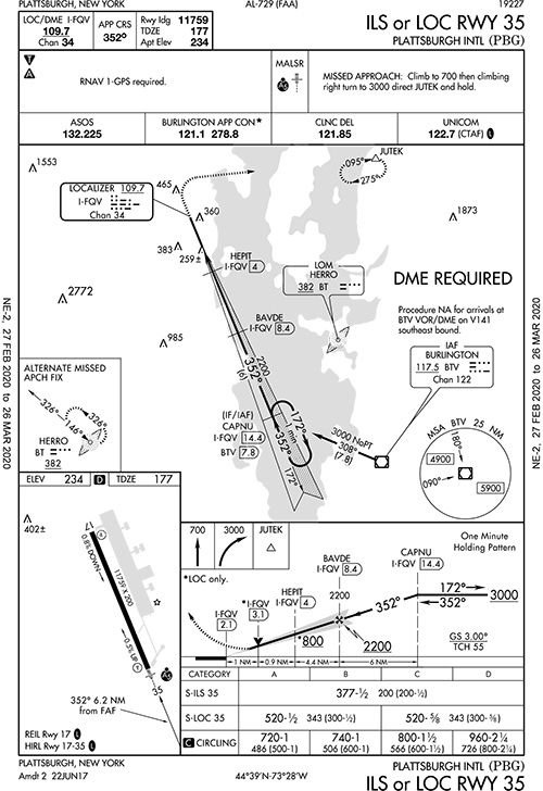
As you noted, the requirement for RNAV is to get to JUTEK. You might note that JUTEK is a fix on V487 from Burlington VOR/DME (BTV), but there’s no way to get to that fix easily on the miss. Hence the use of RNAV. “RNAV 1” is a performance-based-navigation specification as explained (a bit) in AIM Chapter 1, Section 2, “Performance Based Navigation and Area Navigation.”
As for getting busy, that’s kind of the name of the game. Most ground-based approaches require you to do a lot of things, seemingly at once, on the missed approach while you—oh yeah—continue to fly the airplane.
One trick we use for something like this is to simply pick an approximate heading, here perhaps 080 degrees, rather than also worrying about switching nav sources during a 323-foot climb. So, we’d climb straight ahead to 700 feet as we attempt to clean up the airplane. To be honest, we might even exceed that turn point a bit just with handling the airplane.
Anyway, once ready, just turn to your predetermined heading and continue your climb. Then, take a breath and reset the box to intercept the course. You need not be precise as long as you’re reasonably quick. Note that this technique works not just here for switching to RNAV, but also for a ground-based fix that requires switching nav sources.


