
ARCTAN(Height/Base)=Angle
In Lee Smith’s April 2014 article on Visual Area Protection, I think there is an error. The diagram indicates that the 20:1 slope is the same as standard three degree VDA. My memory, Lee Smith’s original “Danger Below MDA?” from March 2013, and my math indicate that 34:1 is the same as a three degree slope.
Jim Kelly
San Francisco, Calif.
We certainly make our share of boneheaded mistakes—we’re pilots, after all—but this isn’t one of ‘em. First, don’t confuse a slope percentage with the angle. So, while a 34:1 slope might be close to three percent, that’s not the same as a three-degree angle.
The article you reference says the 34:1 slope is the obstacle clearance surface that’s evaluated for a three-degree, 20:1 slope, not the three-degree slope itself.
Last, we dusted off and reviewed some long-neglected high-school trigonometry. For a right triangle with base of 20 and height of one, the angle is arctan(1/20) or 2.86 degrees. A little loose rounding gives us our standard three degrees (which is actually closer to 19:1, but TERPS uses 20:1).
Reading Radar
I was reading the May 2013 article on a Florida panhandle flight by Tim Vasquez. It sounds as though he was able to use the NEXRAD info to pick his way through the weather. I had the impression that in a particular cell on a return, all areas shared the same probability of severe weather as its highest area of intensity. So, a yellow or green area in a cell that contained red still had a high likelihood of having the worse convective activity. I believe this information came from the Rod Machado IFR text.
I have only had my IFR ticket a few years and still find this weather interpretation stuff very confusing. However, I would have seen that pretty solid area of yellow and made a no-go decision.
Dave Randall
Springfield Mo.
Your approach is certainly more conservative, and you’ll definitely never go wrong with conservative weather decisions.
Radar’s colors represent areas of increasing intensity. Intensity is simply the amount of material in there that is reflecting the radar back to the antenna. Conventional wisdom is that green isn’t a problem, yellow is caution and red should be avoided while magenta instills fear. But, those colors are an indication of what’s happening at that instant.
I suspect Machado is offering conservative advice and possibly commenting on the NEXRAD delays. If you see a yellow image and the storm is building or moving in your direction, that could indeed be magenta when you get there. But, if the storm is dissipating or moving away, that could be clear skies when you get there. It also depends on what’s inside as some precip reflects more radar energy than other types.
Radar is an imperfect tool. In addition to color, you’ve got to look at cell movement and the intensity over time to determine the stage of the cell, and understand what might be actually reflecting the radar.
NEXRAD isn’t a surgical instrument. You don’t see what’s happening now. Instead you see what happened some time ago. So, again, the advice to avoid those areas is sound but more conservative than necessary in some circumstances. As stated in this issue’s Remarks, we try to avoid that blanket conservatism and drill down to give you more details for your decision.
One last thing to consider is altitude. Are you viewing a base-reflectivity image or a composite image? (See Tim’s article, “Radar Revealed” in June 2014.) Does the image you’re seeing represent any weather at all at your altitude? Perhaps you’re above or below the storm? I’ve nonchalantly flown above magenta returns (not always a good idea) and below. You simply want to avoid flying through the bad stuff.
You just don’t have all the information you need from a lone image. But, if you wish to make a decision on that lone image, it’s safest to avoid that area. That may be overly conservative and cause you to skip a flight that was quite practical and could have been safely and comfortably flown. Or not. You don’t know.
Go Slow When Light
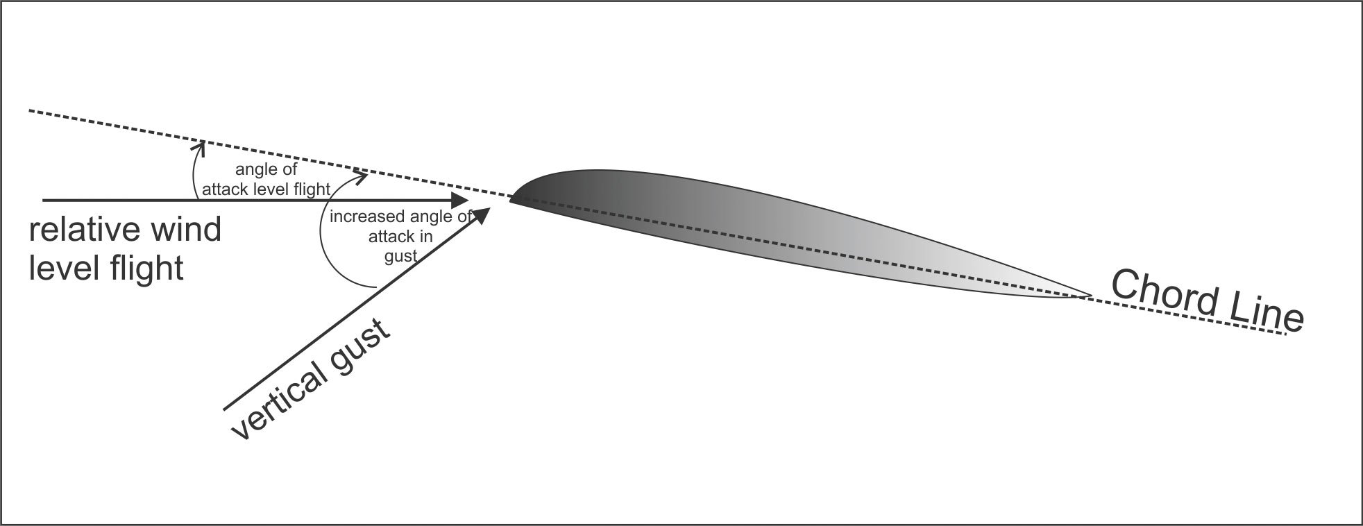
After an encounter with a nasty rotor in the lee of Mt. Whitney many years ago, I have a heightened interest in understanding maneuvering speed. I believe “Turbulence V-Speeds” in March 2014 glossed over why maneuvering speed decreases with weight.The relevant issue is the change in maneuvering speed in the aircraft at different weights.
Imagine a 172 lightly loaded, cruising level at 100 knots. Then let’s load up that same airplane with several hundred additional pounds, and cruise again level at 100 knots. Because of the additional weight, in order to maintain altitude, the aircraft must have additional lift. Lift comes from speed and angle of attack. In order to get the additional lift at the same speed, you have to fly it at a higher angle of attack, requiring increased power. At the heavier weight and the requisite higher angle of attack, that 172 at 100 knots is closer to stalling than at the same speed when lighter.
Now throw in turbulence, and the heavier 172 will stall sooner (with less added g-force), unloading the wings, than it will at a lighter weight. So, at 100 knots, the lighter 172 will incur more load and more stress before it stalls. If you slow the lighter aircraft, you’ll need more angle of attack to maintain lift, and the same turbulence load will now stall the wing rather than break it, just like at the higher weight and speed.
Crista Worthy
Managing Editor, Pilot Getaways
Hidden Springs, Idaho
The article did cover that, but space constraints prevented much detail. The take-away was intended to be the importance of VB. As a result, we abbreviated and simplified some of the explanations.
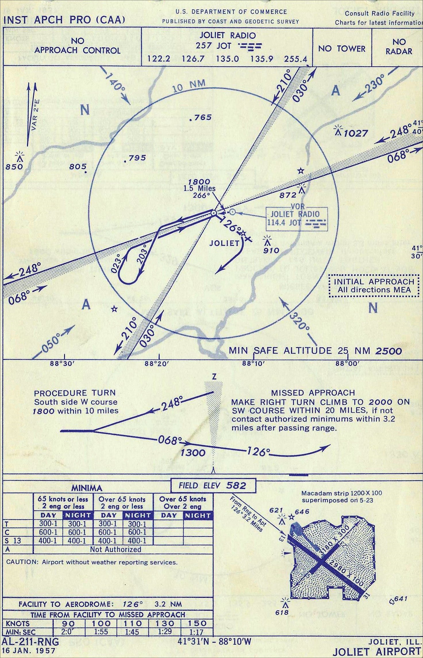
Going to POT
The approach chart in Killer Quiz in the April 2014 issue lists an NDB with the identifier JOT and a VOR, also JOT. The Morse code listed for the NDB is correct, but the Morse code for the VOR reads POT. Is that an error?
Mike Miller
Goffstown, N.H.
Wow, good catch, Mike. Yes, that chart shows the JOT VOR with the incorrect Morse code of POT. We’ll notify the U.S. Department of Commerce so they can direct Coast and Geodetic Survey to issue a correction right away.
We read ‘em all and try to answer most e-mail, but it can take a month or more. Please be sure to include your full name and location. Contact us at [email protected].


