
According to recent FAA statistics, there are approximately 1292 “plain vanilla” ILS approaches that are designed to Cat I minimums—usually a DH of 200 feet AGL and visibility of ½ SM. This excludes Cat II and III and Cat I ILS approaches requiring Special Authorization. Most ILS Cat I approaches also provide minimums for a LOC approach designed to an MDH. Usually, Circling Minimums, also designed to an MDH, are provided.
While there are 1349 approaches with LOC minimums, we can conclude that roughly 57 approaches are LOC only. Excluded are Localizer Directional Aid (LDA) approaches and other LOC-BC, LOC/DME, LOC/DME BC approaches.
The city of San Luis Obispo, California, is approximately 135 NM northwest of Los Angeles and is located a few miles from the Pacific coast with surrounding mountainous terrain. San Luis County Regional Airport (KSBP) has an ILS and a LOC approach to Runway 11.
These are unique because each has its own approach chart, in lieu of the traditional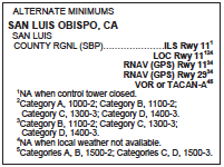 presentation on the same chart. Usually, the main difference between co-charted ILS and LOC approaches are minimums, and for the LOC approach, perhaps, stepdown fixes along the intermediate and final approach segments. Having a single chart also implies that almost everything else is the same, including the missed approach procedure. With separate procedures here, we can assume there are interesting things to find.
Takeoff and Alternate Mins
It is rare that the Standard Procedure Note Box [A] of the ILS is left empty other than indicating the airport has non-standard take-off minimums and alternate minimums![]()
 and alternate minimums
 ![]() . It also indicates that Circling is not authorized north of Runway 11-29 [B]. The reason is obvious: The terrain to the north rises to about 3000 feet MSL or about 2800 feet above the airport elevation of 212 feet.
. It also indicates that Circling is not authorized north of Runway 11-29 [B]. The reason is obvious: The terrain to the north rises to about 3000 feet MSL or about 2800 feet above the airport elevation of 212 feet.
Assume you are flying to another destination but want to use San Luis County Airport (KSBP) as an alternate; recognize that non-standard alternate minimums apply. For non-standard alternate minimums, refer to the U.S. Terminal Procedures Publication.
When filing an airport as an alternate, it is essential to note that you are not just choosing an airport as the alternate but rather a specific approach to a specific runway. Alternates are always required for flight under IFR except for the 1-2-3 exception rule—§91.169. You should also identify from weather forecasts the most likely runway to use at your ETA at the alternate to select the most appropriate approach.
For the purpose of filing an alternate at KSBP, neither the ILS nor the LOC approach is authorized if the tower is closed. However, for Cat A airplanes flying the LOC approach, the alternate minimums are 1000-2 and for Cat B 1100-2, as opposed to the standard 800-2 for non-precision.
There is no such restriction listed for the ILS, so it has the standard minimums of 600-2. Additionally, for the LOC approach the local weather needs to be available but not for the ILS. This is very subtle because we still file “alternate airport” and not a specific approach. Interestingly for the RNAV approaches (there are two), the tower can be closed. We assume the ILS and LOC approaches require the tower to monitor the ground-based navaids (LOC and GS), which is not an issue with RNAV approaches.
ATC Implications
It is common for ATC towers in Class D airspace to be part-time, in this case, San Luis Tower [C] . However, much less common is part-time Approach Control, in this case, Santa Barbara Approach [D]. The Santa Barbara airport is located approximately 63 NM miles to the southeast. The operating times for Santa Barbara Approach are found in the Chart Supplement. The San Luis Tower is open from 1400 to 0400Z, and Santa Barbara Approach hours are 1400 to 0700Z, later than San Luis Tower. After hours Los Angeles Center takes over for Santa Barbara Approach on 119.05 MHz.
 Besides knowing the times of operation of each facility, the frequency for LAX Center is not
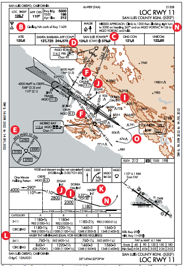 on the approach chart but is in the Chart Supplement. Additionally, the LAX Center frequency is listed on the Low Altitude Enroute Chart. However, if on an IFR flight plan, you would be talking to ATC and they’d give you the right frequency.
But if you are arriving VFR after Santa Barbara closes, it becomes awkward and challenging trying to access the Chart Supplement in the dead of night. Another option for VFR near the airport is to make blind position reports on San Luis Tower frequency of 124.00 MHz, which also acts as the CTAF.
According to the Chart Supplement, when the tower is closed, the Class D airspace turns into a Class G instead of surface-based Class E. This implies that when the tower is closed, there is no weather observer on the field. Had there been a weather observer, the airspace would become surface-based Class E.
Minimum Sector Altitude
While the airport elevation is 212 feet, the four-quadrant MSA [E] shows relatively high altitudes, especially due east and within 25 NM from the Morro Bay VORTAC (MQO). The brown shading shows the higher elevations to the north, east, and west of San Luis. The maximum elevation within the chart is 3198 feet, which is almost due east of the airport. When there is brown shading on an approach chart, sometimes it is a challenge to read details on the planview. Later we will see how the terrain affects the approaches.
Minimum Operational Network
San Luis airport is a MON Airport, and this is indicated on the Low Altitude Enroute Chart as well as on the Chart Supplement. The MON is a network of key VORs that backup GPS navigation in case of GPS outage. The network provides VOR-to-VOR navigation for aircraft above 5000 feet AGL.
Additionally, at least one MON Airport must be reachable within 100 NM. A MON Airport must have at least one ground-based approach and can’t require GPS, DME, ADF, or surveillance (radar vectors). This is the worst-case situation when not only GPS is out but so are ATC radars, a highly unlikely combination. That provides the ability to transition from the en-route structure based on VORs to an approach based on ground navaids. Both PRB and MQO VORTACs are part of the VOR en-route structure defining Victor airways. Additionally, each VORTAC has flyable routes to CREPE IAF [F] . Flyable routes have distance, altitude, and course information.
The ILS Approach The ILS approach has several interesting aspects. The minimums box [G] only offers a straight-in approach and landing on Runway 11; no minimums are charted for non-precision or circling approaches. The minimums are standard ILS CAT I: DH of 200 feet (DA 398) and visibility of ½ SM. When not flying the glideslope (GS), the note [H] points to the chart for the LOC RWY 11. While many Outer Markers (OM) have been phased out, an OM survives at San Luis [I]. It is also the fix, DOBRA. If the ILS approach is loaded in a GPS navigator, neither the OM nor DOBRA show up because they are not part of the approach.
Furthermore, there is no Maltese Cross charted. A Maltese Cross depicts the Final Approach Fix (FAF) for non-precision approaches. For precision approaches, the FAF is GS or GP (glidepath for GPS approaches) interception. This confuses some pilots since the non-precision localizer version with its Maltese Cross at the FAF is usually on the same chart as the ILS. It used to be common for the localizer FAF to be in a somewhat different place than the ILS FAF, but recently the FAA has been charting these so they’re the same, where possible.
There are two ways to fly the approach starting at CREPE. The GS over CREPE is at 4328 feet MSL. Passing CREPE, stay at 4000 feet MSL, intercept the GS and follow it down to the DA at 398 feet MSL. The other way is to dive and drive from CREPE to 2400 feet MSL, level off, and then intercept the GS and follow it. This method just destabilizes the approach with little real benefit. However, the charted lightning bolt indicates the lowest altitude (2400 feet MSL) for GS interception, the FAF.
The Localizer Approach
The LOC approach is a bit more complicated. In the intermediate segment (between CREPE and DOBRA) there is a step-down fix ZEGAX [J] that must be flown at or above 2800 feet MSL. DOBRA [I] also has to be overflown at or above 2300 feet MSL.
 On the final approach segment between DOBRA and the runway threshold (the missed approach point) there is another step-down fix: HASBY [K].
 However, HASBY is an “optional” step-down fix because, if identified, the MDA is 760 feet MSL compared to 1180 feet MSL, if not identified.
The minimums section [L] specifies that DUAL VOR RECEIVERS REQUIRED specifically to identify HASBY while on the localizer, which then results in lowering the MDA by 420 feet. However, it seems that a second VOR receiver is handy to also identify ZEGAX.
Additionally, DOBRA also needs a second VOR, however, the Outer Marker can be used to identify passing over DOBRA. Of course, all this can be avoided by loading the approach in a GPS navigator, which then allows GPS to substitute for a VOR (AIM 1-2-3) permitting easy identification of ZEGAX and HASBY.
ILS and LOC Difference
One difference between the precision and non-precision versions is how the intermediate and final approach segments are flown, which is typical in any ILS or LOC approaches. But the biggest difference at KSBP is how the missed approach is flown. On the ILS version, the missed approach segment starts on GS at DA of 398 feet MSL [M] about ½ SM before the threshold of Runway 11.  On the LOC version, the missed approach segment starts at the runway threshold [N] at the MDA of 1180 feet MSL or 760 feet MSL, depending on if HASBY has been identified.
  Let’s take the worst-case scenario where the LOC missed starts at 760 feet MSL. At that point, the airplane is already 362 feet higher compared to the ILS DA. This allows starting a turn sooner to intercept the MQO radial-126 inbound [O] to MQO for the missed approach hold. For the ILS missed, a southerly heading is required to intercept the MQO radial-126. [P] Note that mins on the localizer are above the 674-foot obstacle south of the end of the runway, but the ILS mins make that a concern requiring a different path.
 In Summary
When flying to any new airport, especially one in a mountainous area, it is not only important to study the possible approaches but also to understand the surrounding terrain. Sectional charts, and departure and arrival procedures are useful, as are the low-altitude enroute charts and even Google Earth. It is also a useful best practice to review comments in the chart supplement for additional information not found elsewhere.


