
Departures into low clouds might not be your thing, and that’s fine. Staying on the ground is the ultimate risk mitigation for absolutely any concern. But departing in IMC is common practice and can mean anything below three statute miles of visibility and/or ceilings below 1000 feet.
That’s a wide weather window when deciding if it’s okay to launch. Applying personal minimums for takeoff, often matching approach minimums, is another common choice. It’s also good practice to brief an emergency-after takeoff turnback that stays in VMC. Even then, such plans can’t cover every situation, so one of the biggest risks is actually being forced into a quick decision for an unexpected problem.
Waiting It Out
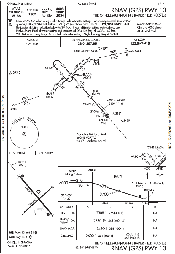
It happened when leaving O’Neill, Nebraska, elevation 2034 feet. Yesterday you flew the LNAV to Runway 13, and broke out well above the mins of 2420- 1 with the airport in sight soon after AKIGE. But with overnight moisture, today it’s down to 200-. in mist. That’s below the LPV minimums for Runway 13 and 31, so you’ll just have to wait. You want at least three miles of visibility along with the highest published MDA for the approach in use; hence you refer to the RNAV (GPS) RWY 13’s circling MDA of 2600-1—almost a 600-foot ceiling—which you learned from practice is just good enough to circle back if something catastrophic happens.
An hour later, the weather is lifting, so you fire up. It’s 500-2, and expected to reach your magic 600-3 by the time you have a clearance. For your filed route northeast to Minneapolis, you look up Center’s telephone, but it’s inop. At nontowered airports you’ll often depart VFR and get a clearance in the air. Not today; it’s too low.
You open the airport’s com details and see that Minneapolis Center’s frequency is 128.0. This is called “O’Neill RCAG.” What’s RCAG? Is it like an RCO (Remote Communications Outlet), using the radio on the ground, or is something different?
RCAG is defined in the AIM 5.3.1.a., Direct Communications, Controllers and Pilots. “Maximum communications coverage is possible through the use of Remote Center Air/Ground (RCAG) sites comprised of both VHF and UHF transmitters and receivers. These sites are located throughout the U.S. Although they may be several hundred miles away from the ARTCC, they are remoted to the various ARTCCs by land lines or microwave links.” The “maximum communications coverage” sure sounds promising, so you call on the radio and it works as expected. Cleared as filed: Off Runway 13 and direct LLUKY, a fix just northeast of the field to help set the en-route course to the Mankato VOR (MKT in Minnesota, not TKO in Kansas), then MSP. The void time is generous: 15 minutes to depart, and 10 to call if you don’t.
Bad Luck
After carefully performing the pretakeoff checks, you also confirm obstacle departure procedures for Runway 13: “climb heading 130 to 2600 before turning.” That’s 566 feet AGL based on the airport elevation to clear towers to the east and southeast. So bug 2600 feet on the altimeter, and bug runway heading, planning a left turn after 600 feet AGL to LLUKY.
By now it’s up to 600-3. Great. Now for the emergency-after-takeoff brief: In case of a low-altitude problem with your only engine, or a malfunction preventing flying an approach back to the runway, have a procedure for each situation. Today, it’ll be a right turn to avoid the obstacles, and an emergency landing on the airport, whether it be Runway 4, 13, or any suitable surrounding surface if it comes to that.
Runway 13 is 4408 feet long, and you’re airborne before the 4/22 intersection. The mist soon cuts visibility to under a mile at 2500 feet indicated. Just then, the GPS screen goes black. It’s a split-second call. You level off quickly at 500 feet AGL to stay below the ceiling. Not good, but flying the airplane comes first and you decided it’s best to keep a visual on the runway. You reduce power, slow down, and lock in 2500 feet on the altimeter. Should you continue the climb into IMC? Decide.
The GPS was also the primary com, so you swap to com 2, which you’d already tuned to Minneapolis Center and the on-field O’Neill VORTAC with 055 on the #2 indicator for V250 to approximate your RNAV course in case GPS failed. What next?
That low cloud layer might not be more than 1000 feet thick, offering a brief climb to a safe haven. The only other option is to fly a low-level emergency right-turnback and land. Indecision is wasting time, so you choose to start a right turn for the downwind to 13 and prepare to set down.
Down? Or Up?
The downwind leg buys a few seconds to reconsider getting higher. What’s riskier now—a low, tight, descending circle to 13, or maintaining 2500 feet ’til you can make a U-turn to runway heading, then climbing out and picking up the course? You’ve still got a clearance on course (about 050 degrees). Maintain 5000 feet. Expect 9000 feet 10 minutes after departure. Using just one VOR receiver and CDI, can you make it work? Technically, LLUKY is an RNAV fix terminating the low-altitude T-route (T302), so that’s out of the picture.
The O’Neill VOR connects to the Yankton VOR on V250, which is just a few degrees right of the original GPS course. If you stay on the 050 course and keep the airway just to your right, you’ll maintain positional awareness, call ATC as soon as you can and explain. (Worry later about skipping VOR checks and violating 14 CFR Åò91.171).
Now, a mere 20 seconds have elapsed since takeoff, so Center has yet to suspect anything’s amiss. Can they hear you? Probably, using the RCAG. Can they see you? Probably not yet with the Minimum Vectoring Altitude, per the chart overlay, at 3700 feet. Back to aviate: Turn upwind now, wings level at 2500 feet, and pick up where you left off.
Can you use the autopilot to help maintain a track? Sure, just be ready with control wheel steering to adjust bank and pitch to keep a visual on the runway. Now you can navigate. Preselect 5000 feet, start climbing and track the northeast course. Next, communicate. A cheerful Minnie controller greets you at 3700 feet and listens to your troubles, then asks intentions. You have VOR, so could you get a slight route amendment and follow V250 to Mankato, and pick up an arrival from there? Sure. At this point you did comply with 91.187 and reported the malfunction along with your plan of action. You’re a bit in the grey with 91.123, “compliance with ATC clearances,”as you deviated (in an emergency?) from the expected climbout.
Once on top (and breathing more easily), you regroup again. The Plan B for a circling approach after takeoff wasn’t there for lack of GPS, but it worked to buy some time to decide the next action. You also had available (and still knew how to use) the secondary navigation system and remembered you had an autopilot. Lesson learned, which you’ll describe in detail at home on a NASA report that will disclose your equipment failure and its result.
And, you raised personal minimums to 1000-3 for IMC departures, then added VOR checks to your procedures. It’s less risky and more legal.


Why not just land, regroup about the nav plan and requirements, and then decide to take off or not. Vfr and airport in sight is better than cfit because you made a rushed mistake switching to vfr navigation.
Agree with Tim. Failure of any instrument places it’s power source (in this exercise the electrical system) in question. Under a low ceiling with things happening quickly and the runway in sight, aborting the flight looks like the a better choice. Also, what’s the rush, weather is slowly improving and sorting through failure cause, remediation and change of flight plan is a stress free task when done on the ramp.
As a matter of fact, I do agree, IMHO, with Mr. Tim.
‘Tis better to be on the ground wishing you were flying…” Having ground contact is the deciding factor. If you can see the ground and reasonably navigate to the runway, land. Cause of the system going TU is unknown at this point, better to just put ‘er down and go have a beer. Or two. No brainer.