
In this reintroduction of a past series of articles, we’ll fully dissect a particular chart or procedure. While many of the points we’ll make should be uncovered in a normal briefing, our analysis will extend far beyond. Our hope is that by exploring the edge cases of available procedures, you’ll better understand how to handle something that’s not quite in the mainstream of procedures you regularly fly.
The first chart in this periodic series is the rather odd LOC/DME BC-B approach at Medford, Oregon, KMFR. Let’s walk through it point by point. (To follow, match the highlighting colors on the chart (next page) to the text.)
Title and TCH
Just the name gives the first indication that this is an “interesting approach.” To fly the final approach segment requires a LOC as well as DME; however, an IFR GPS can be used in lieu of DME, assuming that the fixes are in the GPS database. But that’s not all; it also uses the LOC back course (BC) making it a non-precision approach since it lacks a glideslope and is flown to an MDA (Minimum Descent Altitude).
The localizer is lined up with Runway 32 but the approach isn’t identified with the runway but is designated as “-B.” While it is a straight-in approach, it has only circling minimums. It fails one of the conditions for a straight-in landing: “The descent gradient is greater than 400 feet/NM from the FAF to the threshold crossing height (TCH)”. (FAA Instrument Procedures Handbook 4-11.)
It is 633 feet/NM and notice the descent angle is 5.98 degrees, almost double the standard three-degree glideslope angle. However, if the runway or the other nine items specified in §91.175 are visible from a prudent distance, a straight-in landing can be legally made.
Elevation
The airport elevation doesn’t seem very high for a mountainous area (1335 feet MSL). But the airport is surrounded by mountains and specifically from the east clockwise to the west of the airport, precisely where the BC segment is located. The highest elevation on the approach chart is due east of the airport at 9495 feet MSL (Mount McLoughlin). NW-1, 03 DEC 2020 to 31 DEC 2020 NW-1, 03 DEC 2020 to 31 DEC 2020 The MSA (Minimum Safe or Sector Altitude) based on the Rogue Valley VOR (OED) is another indication of the elevation of the surrounding terrain.
It is always a good practice to also look at the sectional chart to get a more expansive view of the terrain. A good indication of the elevations surrounding the airport is the amount of “brown color” on both the approach chart and sectional.
Getting There
The intermediate and final approach segments starting at ASHIE (IF/IAF) to the runway threshold add up to 18.8 NM, a fairly long distance. Along the course, there are three step-down fixes that are clearly seen in the profile view. However due to chart clutter and the terrain shading, the step-down fixes can be difficult to see on the planview.
Minimums
The MDH (Minimum Descent Height) is relatively high at 2205 feet AGL with a required visibility of 1¼ SM or 1½ SM for Category A and B aircraft, respectively. If the runway environment is sighted at or near the missed approach point (JIPTO), the runway threshold is only 0.7 miles ahead. It would require a rather steep descent of 2205 feet in .7 miles giving us a scary 27-degree descent angle, which would make any self-respecting roller coaster blush and surely shatter “normal maneuvers” of §91.175.
If a straight-in landing is to work out, the final descent needs to start sooner than JIPTO, perhaps four miles from the runway threshold; it will still be a rather steep descent of 551 feet/ NM. From a technique perspective, it is truly a dive-and-drive profile. From the FAF (HOXOR) altitude of 7200 feet MSL, it requires a quick descent to the MDA of 3540 ft. to hopefully see the runway sooner rather than later.
On the Missed
If a missed approach is needed, fly and climb straight ahead for 7.9 NM to OED and hold. It might require you to continue climbing in the hold if you’re not able to climb at a gradient greater than 514 feet/NM, which could be challenging for many aircraft.
Little, But Important, Details
This approach also has alternate takeoff minimums and it is natural to wonder why they would be relevant since we are doing an approach. They are potentially relevant for the missed approach. A climb gradient of 260 feet/NM to 6800 feet MSL is required or a visual climb (VCOA) is permitted when the ceiling is 2900 feet with a visibility of 3 SM. Also, an obstacle departure procedure (ODP) is listed but if the missed is flown as charted, the ODP does not provide a constraint.
This approach also has non-standard alternate minimums. A tricky question for an IPC is: what are the alternate minimums for XYZ airport”? The reality is alternate minimums reflect specific types of approaches and runways not just the airport. In Medford, the non-standard minimums for this approach are listed as N/A if the tower is closed and Category A and B aircraft have a ceiling of 2300 feet with 2 SM visibility, while the visibility increases to 3 SM for Categories C and D. An “open” tower is needed to monitor the localizer; but that restriction is not relevant for VOR and GPS approaches.
Back Course Approaches
BC approaches are a lot less common especially since airline airports have ILS approaches to most runway ends and the proliferation of GPS approaches flown to LPV DAs has made most BC approaches obsolete. We always need to set the course selector on an HSI to the front course heading, in this case 143 degrees. When we do that, the geometry of the HSI assures we always correct toward the needle, never away from it.
However, this is only an optical thing because regardless where the arrow points to, it is still providing correct data, but appears more logical to the brain when set correctly to the front course.
What about the autopilot? Most APs have a BC mode that needs to be selected for a coupled approach, otherwise it’s likely that when intercepting the LOC course, the airplane will turn to fly the LOC to the front course heading—away from the runway. Be sure to review the AFM supplement for your autopilot for the proper way to manage the autopilot to fly a BC.
A Better Alternative?
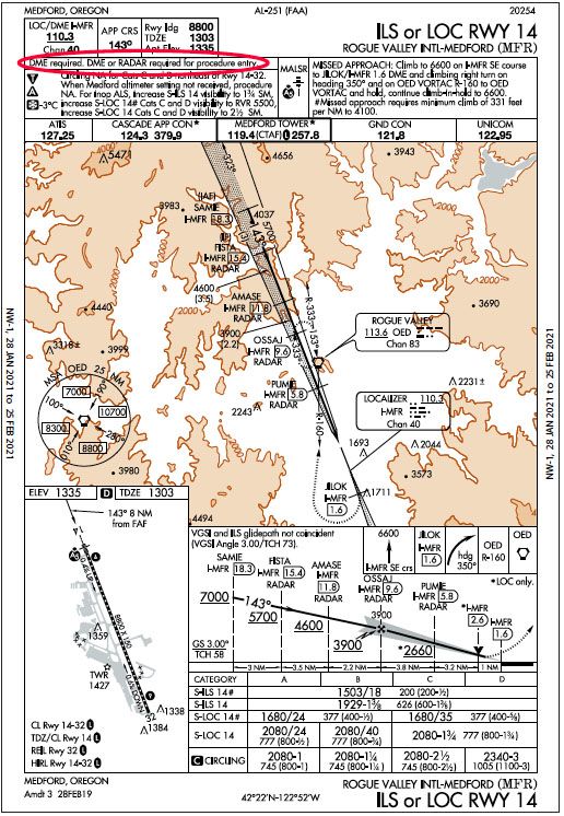
I typically don’t recommend circle-toland approaches due to their inherent higher risk compared to straight-in approaches and landings. However in this case, I would recommend, instead of the LOC/DME BC-B approach, the ILS or LOC RWY 14 circle-to-land Runway 32. We are, of course, assuming winds strongly favor Runway 32. Flying it as an ILS approach offers several benefits.
Flying the Runway 14 approach as a LOC approach involves a number of step-down fixes, but the step-down fixes “disappear” because we can fly the glideslope all the way to the circle-to-land MDA, in other words we fly it as an ILS. The MDH for the ILS approach, circling option, is 745 feet AGL vs. 2205 feet AGL for the BC-B approach. Since we are landing on the opposite runway, when ready to circle, enter the left downwind and land. Left downwind is better since the runway is more visible to the pilot from the left seat.
Also notice that the ILS approach has the annotation: “DME required. NW-1, 28 JAN 2021 to 25 FEB 2021 NW-1, 28 JAN 2021 to 25 FEB 2021 DME or RADAR required for procedure entry.” Typically, when additional equipment is required for the approach, but not for flying the final approach segment, it would simply state: “DME Required.” Now a reason for the additional equipment is mentioned. Expect these annotations to appear over time on more approach charts as new chart versions are published.


Excellent analysis of these two approaches. Flew both of these approaches regularly back in the day. If not
flown precisely and at too fast a speed, a GPWS warning could easily occur. Thanks for well done article.