Grider Field (KPBF), Pine Bluff Regional Airport, Arkansas, is located approximately 36 NM southeast of Little Rock Airport (KLIT). The airport is named after J. McGavock Grider, an American WWI fighter pilot who flew for the British Royal Flying Corps, later the Royal Air Force. The municipal airport dates back to 1941, built as a primary flight training airfield for the U.S. Army Air Force (USAAF). Approximately 9000 cadets were taught under contract with a local flight school during WWII.
Pine Bluff Airport is a nontowered airport that has a single runway with GPS approaches to both ends and an ILS or LOC to Runway 18. It’s interesting that there are the two ways to fly to the ILS final approach course without using vectors-to-final (VTF).
Getting on the Approach
You can get to an initial approach segment without VTF via one of two DME arcs, and a “teardrop track” (TDT). This approach does not have “flyable routes,” to take an aircraft from an en-route to a terminal environment. A flyable route is charted as a bold line with a heading, distance, and minimum altitude. I mention this because some believe a DME arc is considered a “flyable route.” More on this later.
Teardrop Track (TDT)
The TDT is more common at non-U.S. airports because radar services are often unavailable. The TDT typically requires a VOR, VOR/DME, or VORTAC on the field. In the case of a VOR approach, fly outbound on a VOR radial, then at a specific distance reverse direction and intercept a different inbound radial, usually requiring a change of heading of approximately 200 degrees, creating the teardrop track.
At Pine Bluff, the VOR/DME [A] is about four NM north of the Runway 18 threshold, slightly east of the extended runway center line.
Using ground-based navaids, DME is explicitly required [B] to identify NETAA [C] at 12.4 DME using the PBF VOR/DME. Then there’s a left turn to intercept the localizer, which provides the lateral guidance to the runway. It also implies that the nav source needs to change from PBF to the I-PBF localizer. Most GPS navigators can automatically switch from GPS navigation to LOC near the localizer. However, I have not seen automatic switching from a VOR source to a localizer. In this case, we must manually change the navigation source, which could also involve a frequency change that, wherever possible, should be tuned in advance.
Additionally, since we are using VHF navigation for lateral guidance (LOC and VOR), we must first verify the source by listening to the Morse code identifiers. [D] Alternatively, some VORs have recorded automatic voice identification, which is always indicated by the name of the VOR, followed by the acronym “VOR.” Per the AIM, some VHF navigation equipment decodes the LOC and VOR identifiers, so you don’t have to listen to the code.
The Notes box states, “DME requires simultaneous reception of I-PBF and PBF DME.” [E] This is potentially confusing, but essentially means you’ve got to be able to receive the DME from PBF at the same time you receive the localizer, I-PBF. Usually, this implies two VOR receivers are required since the DME UHF frequency is tuned by its paired ghost VOR VHF frequency. However, some DMEs can be tuned directly or can hold the previously tuned frequency; requiring only one receiver. With only one VOR/LOC receiver, the frequency needs to be switched from VOR to LOC as we turn to intercept the LOC. (Note: the LOC does not have a co-located DME.) Interestingly, the approach still has an outer marker that doubles as a LAT/LON waypoint—TUKER—and the non-precision Final Approach Fix (Maltese Cross). [F]
To fly the TDT use GPS or VOR directly to PBF, then to NETAA [C] , and turn left onto the LOC. However, we must follow LOC guidance, not GPS, to fly the final approach segment from the glideslope intercept to the runway.
Using GPS or VOR navigation, we must be mindful of the intercept angle to fly the outbound 022-degree PBF radial. If we approach PBF from the northwest to the northeast, the intercept angle is likely too acute for a smooth capture. With GPS, we might get enough “turn anticipation” to gracefully intercept the inbound radial. Of course, VOR navigation alone doesn’t provide turn anticipation.
DME ARC Procedures
Another way to reach the final approach segment is to fly one of the DME arcs. Let’s call the left one the clockwise (CW) arc [G] and the other the counterclockwise (CCW) arc. [H] With GPS, it’s easy. Depending on location (east or west of the airport), when loading the approach in the navigator, select the most convenient initial approach fix: IYUNE [I] or IYTEL. [J} That also loads the approach and the relevant arc.
However, notice that both IAFs are shown with a triangle symbol, indicating they most likely serve as VOR en-route fixes. The Enroute Low Altitude chart confirms that both fixes are part of two airways: V16 for IYUNE and V74 for IYTEL.
Sometimes I get questions like, “can ATC vector me to a waypoint or fix?” The answer is “no” because vectors (besides vectors for traffic or separation) are not that precise; they can only head you to a course.
The CW arc has a step-down fix (CACAC) [K] lowering the altitude from 3700 feet MSL to 2000 feet MSL, which is the target altitude at the intermediate fix (IF) REYLO. [L]. Interestingly, the minimum en-route altitude (MEA) on V16 near IYUNE is 2000 feet. Presumably, if at 2000 feet MSL on V16, we would need to climb to 3700 feet MSL before reaching IYUNE and starting the arc. The CCW arc does not have stepdown fix. However, since the arcs don’t (quite, in this case) intercept the intermediate segment at a 90-degree angle because PBF doesn’t quite lie on the final approach course, both arcs have lead-in radials (LR-338 [M] and LR-008 [N]) to allow a smoother intercept with less chance of overshooting.
Regarding the question: Is a DME arc a flyable route that takes an aircraft from the en-route structure to a terminal environment? The general answer is “no” since an arc’s starting point is usually an IAF where the initial approach segment begins. However, in the case of Pine Bluff, an argument could be made that while the approach technically does not have flyable routes, since IYUNE and IYTEL are both en-route fixes, they allow an aircraft to join an initial approach segment from the en-route structure.
Parsing the Minimums
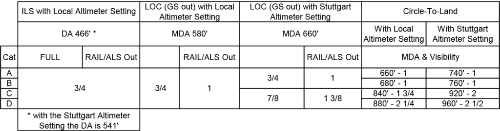
The decision altitude (DA) for the straight-in ILS approach and the minimum descent altitude (MDA) for the LOC straight-in approach have the same values independent of the aircraft approach category, 466 feet MSL [O] and 580 feet MSL [P], respectively. As expected, the MDAs for circling approaches [Q] differ by category to compensate for the wider turning radii of faster aircraft.
I believe that Jeppesen’s approach charts better show in tabular form how DA and MDAs, along with visibility values, change given remote altimeter setting (Stuttgart) and inoperative ground equipment. I recreated the minimums section in tabular format to reflect the text in the Notes box comments. Like the cliché about a picture, “a table is worth a thousand words.”
What is not apparent at first sight is that the DA and MDAs are different if using the remote altimeter setting from the Stuttgart Municipal Airport. Stuttgart is located approximately 31 NM northwest of Pine Bluff Airport.
Alternate Minimums NA
We file an airport code in the flight plan when an alternate is required. However, filing an airport code, we are implicitly selecting one or more particular approaches. In this case, we cannot file Pine Bluff Regional if we plan to use the ILS or LOC RWY 18 approach. The notation N/A [R] indicates that the approach is Not Authorized as a filed alternate because the ILS is not monitored. But we can file KPBF as an alternate if we plan to fly the GPS approaches to Runway 18 or 36. The irony is that the ILS approach can be flown once diverted to the alternate. We simply cannot plan to fly the ILS as our alternate.
Airport Diagram and Lights
The symbol [S] indicates that the approach lighting system (ALS) is a MALSR (Medium Intensity Approach Lighting System with Runway Alignment Indicator Lights or RAIL). RAIL is indicated by the dot on top, colloquially known as the “rabbit.” The symbol in reverse printing indicates Pilot Controlled Lighting (PCL).
Compared to Jeppesen charts, one advantage of the FAA charts is the small airport diagram [T]. Given its size, it usually is insufficient to act as a taxi diagram; however, it offers three relevant features. A small arrow indicates the relationship of the final approach course with the runway (for straight-in approaches) or the airport for circle-to-land approaches. It also shows the “exit” taxiways; landing on Runway 18, all exits are to the right. Last, the diagram helps to plan the track of visual maneuvering for circling approaches.
The airport diagram also shows the layout of the lighting system and indicates that Runway 18/36 has Medium Intensity Runway Lights (MIRL) which are also pilot-controlled due to reverse printing.
Luca F. Bencini-Tibo, with the proliferation of GPS navigators, has not flown with DME in this century and wonders if he would remember to tune a DME if he finds a working unit.
Down in a Hurry
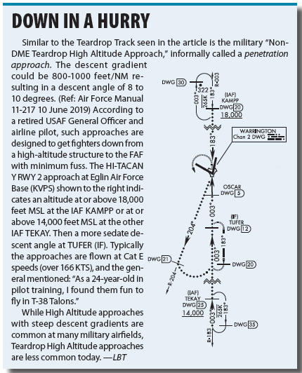
Similar to the Teardrop Track seen in the article is the military “Non-DME Teardrop High Altitude Approach,” informally called a penetration approach. The descent gradient could be 800-1000 feet/NM resulting in a descent angle of 8 to 10 degrees. (Ref: Air Force Manual 11-217 10 June 2019) According to a retired USAF General Officer and airline pilot, such approaches are designed to get fighters down from a high-altitude structure to the FAF with minimum fuss. The HI-TACAN Y RWY 2 approach at Eglin Air Force Base (KVPS) shown to the right indicates an altitude at or above 18,000 feet MSL at the IAF KAMPP or at or above 14,000 feet MSL at the other IAF TEKAY. Then a more sedate descent angle at TUFER (IF). Typically the approaches are flown at Cat E speeds (over 166 KTS), and the general mentioned: “As a 24-year-old in pilot training, I found them fun to fly in T-38 Talons.”
While High Altitude approaches with steep descent gradients are common at many military airfields, Teardrop High Altitude approaches are less common today.