
Runway 7R approaches at Ted Stevens Anchorage International airport (including the missed approach portions) [A] overfly Cook Inlet. The inlet stretches about 180 miles from the Gulf of Alaska to Anchorage and was named after explorer James Cook searching for the Northwest Passage. Today the airport is a refueling stop for flights between North America and Asia, offering the shortest route between many points.
Topography
The airport elevation is 151 feet, [B] but the MSA (Minimum Sector Altitude) is 8800 feet [C], centered on the Runway 7R threshold. From the north counterclockwise, it is surrounded by water: Knik Arm, Cook Inlet, and Turnagain Arm. To the near west, mountains rise up to 7500 feet and within 100 NM elevations reach 13,000 feet due west. Given the topography, approaches (ILS and RNAV) are available to Runways 7L, 7R, 15 and 33. If landing west (Runways 25L and 25R), only charted visuals are available. Oh, and there are volcanos in the area.
Pesky Volcanos
There are about 200 volcanoes in the U.S., and Alaska accounts for about 140. While major eruptions are infrequent, volcanic ash is dangerous for airplanes—it has the effect of flying through a blast of sandpaper and can quickly cause engine failure, especially in turbines. Worldwide, there are eight Volcanic Ash Advisory Centers (VAAC) monitoring volcanic activity and issuing Volcanic Ash Advisories (VAA). Two of these are in the U.S. (Alaska and Washington). The Alaska VAAC covers the Anchorage FIR (Flight Information Region) and the eastern most part of the Russian FIR.
RNAV (GPS) Y RWY 7R
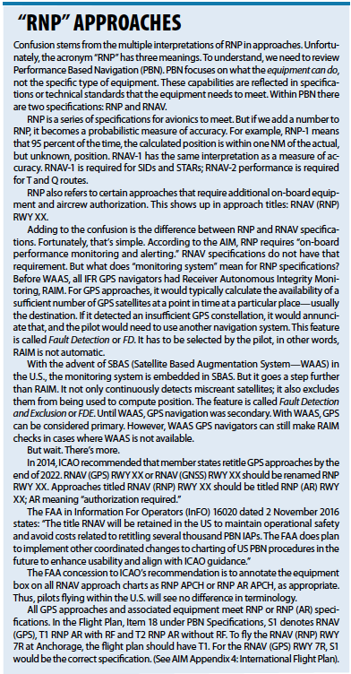
Before digging in, let’s review the annotation in the equipment box [D] , RNP APCH. This can be confusing, even for knowledgeable pilots. I’ve heard such responses as “It’s a typo,” “Absolutely wrong; RNP requires authorization,” “Show me where it says that authorization is not required,” and so on.
The confusion stems from the multiple interpretations of “RNP,” specifically its use in RNAV (RNP) RWY XX approaches. In this instance however, RNP APCH refers to specifications or standards that all IFR GPS navigators must meet to fly RNAV (GPS) approaches. These procedures don’t require authorization or special flight training—RNP APCH are GPS approaches that we have been flying for years. See the sidebar.
Approach Design
 At first glance, this seems to be a typical GPS approach, but there are several interesting aspects. Given the topography, instead of a “T” approach, this is a “Y” approach with IAFs (CEYAB and ECIKI) at the end of the “arms” and an IF WEWWO in between the two IAFs. With the “Y” approach, the turn to the final approach requires a 45-degree intercept; much less than the typical 90-degree intercept with “T” approaches. Usually, the IF is also an IAF that acts as a waypoint for a hold in lieu of a procedure turn (HILPT). This approach has no procedure turn.
Before WAAS, some baro-aided IFR GPS navigators allowed the creation of a glide path. Usually, this option was not available for light GA aircraft. But WAAS navigators without baro-aiding allowed airplanes to fly to LNAV/VNAV minimums [E]. Most approaches with LNAV/VNAV minimums also have LPV mins and usually the navigator (not the pilot) would automatically select LPV over LNAV/VNAV. However, the pilot always has the prerogative to fly to the LNAV/VNAV DH.
The LPV DH and visibility minimum and for this approach are typical [F] (200 feet AGL and RVR 18 or ½ SM). That 200-foot DH is similar to a Category I ILS. But for the LNAV/VNAV approach [G] the DH and visibility (488 feet AGL and RVR 55 or 1 SM) seem high compared to the LPV. Both are approaches with vertical guidance (APV) but are not considered precision approaches because they lack a ground-based glide slope. They are flown to a DH, not an MDH—once at DH without seeing any of the items in §91.175, you should miss. The flight profile is like a “V.” Since the LNAV/VNAV approach has a higher DH using the same glide path as the LPV, the missed approach starts further from the runway, requiring a higher visibility.
Paradoxically, the LNAV visibility [H] is lower than the LNAV/VNAV approach, specifically RVR 24 or ½ SM vs. RVR 55 or 1 SM. The reason isn’t obvious from the profile view. The missed approach point for the LNAV is the runway threshold but the MAP for the LNAV/VNAV is on glide path at DH—about a mile from the threshold. On an LNAV approach delaying the final descent to the runway beyond the VDP compromises the ability to land on a short runway. However, at 488 feet AGL over the threshold of a 12,400-foot runway should offer anything but a loaded heavy a safe landing, assuming compliance with §91.175. Additionally, while not charted as a side-step, with appropriate clearance one could land on the parallel 10,600-foot long Runway 7L using circling minimums [I] .
Note the limitations: “Procedure NA for arrivals at GASTO on V462 southwest bound” and “… at IVANN on V440 westbound.” [J] These would require substantial turns. Plus these are VOR/DME fixes, not fly-by GPS waypoints.
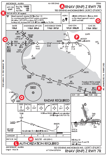
RNAV (RNP) Z RWY 7R
The approach is annotated RNP AR APCH, RF required [K] and on the bottom it clearly states AUTHORIZATION REQUIRED [L]. This approach has several curved paths—the missed approach course and the approach starting at HOPER. The equipment must be certified to fly RF legs (radius to a fix), similar to the DME arcs of pre-GPS days. Unlike DME arcs, RF legs don’t have a charted central point like a VORTAC. (Note: GPS navigators typically fly DME arcs using GPS for distance and azimuth but do require waypoints as center points to define the arc or circle. Some newer navigators support RF legs.)
Interestingly, the visibility minimums are RVR 50 or 1 SM [M], which is higher than the RNAV (GPS) Y RWY 7R LPV approach (RVR 18 or ½ SM) [F] . The missed approach point is at 562 feet MSL (430 feet AGL) on the glide path that requires the airplane to start the missed approach at a higher altitude and further out from the runway. In the LPV approach, the missed approach instructions indicate to first Climb to 900 feet, then climbing right turn… [N] However, the missed for the RNP approach simply states Climb to 3000 … to JUKEP. [O] That implies that upon reaching the missed approach point, the climbing turn starts right away. Due to terrain, there is a need to start a standard-rate turn at the missed approach point or be limited to a maximum 20-degree bank at 230 knots or lower [P] .
 It appears that the LPV would be a better choice given the lower minimums. One advantage of the RNP approach, for properly equipped and authorized aircraft and flight crews, is starting due west at ELIAS [Q] or from the southeast of Anchorage at HOPER [R] . These options aren’t available on the LPV.
Final Thoughts
Before attempting a low-weather approach to an airport that is new to you, especially in mountainous or remote areas, study approach and en-route charts in detail as we’ve done here. Consider also reviewing the surrounding topography using sectionals and Google Earth. Finally, review unusual weather (volcanos?) and NOTAMS. Granted, PANC has more nuances than you might normally find, but uncovering the nuances that exist could be a life saver.


