
In his June 2014 article, “Know Your Height AGL,” Frank Bowlin explained the potential uses of a radar altimeter. As I read that, I reflected on my airline days where we used a pressure altimeter set to read our height above the airport. In contrast to costs of many thousands of dollars for a radar altimeter, some of the same—and critical—benefits can be had for a thousand dollars or less by purchasing and installing an altimeter dedicated to read QFE, or height above the airport. Sometimes QFE is even better.
The Challenge
Let’s start with a basic premise: your situational awareness is improved if you reliably and conveniently know your height above the airport. Armed with this knowledge, it’s much easier to know your traffic pattern altitude, how you’re doing on your descent to the runway without electronic aids, progress on an approach or even when you’ll likely break through that cloud deck. (Remember clouds are reported in height above the ground.)
With that premise as the starting point, how are we going to determine our height above the airport? Well, there’s the radar altimeter, certainly. But there are some circumstances where that can be as challenging to use as MSL altitude, and occasionally even more so. Those circumstances involve highly variable terrain.
Say, for instance, you’re approaching an airport over wildly uneven terrain as you might get in the mountains. The radar altimeter is faithfully reading your height above what’s immediately below. Although potentially useful for terrain avoidance, that information is pretty much meaningless for your approach and landing at the airport because it’s not referenced to the airport elevation and it’s bouncing around like an uncertain stock market anyway.
But, what if you had a regular pressure altimeter that was set to read, not your MSL altitude, but AGL referenced to the airport? That’d be pretty handy.
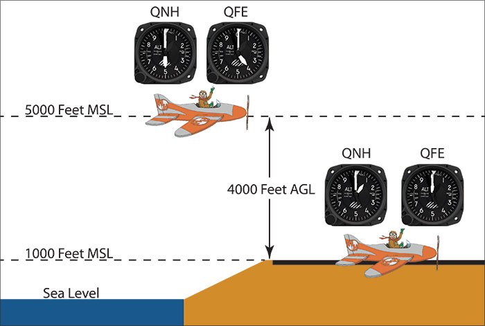
Well, from the “been there, done that” department comes the QFE method of setting an altimeter. “Q” codes, a remnant from the days when radio communication used Morse code, include QFE, the code for altimeter setting referenced to the ground level, just like the setting to the local barometer is QNH and above the transition altitude is QNE.
As it turns out, some of the earliest aviators who couldn’t range far from the airport (OK, the “field”) anyway, really only needed to know their height referenced to the airport, so QFE was a common way of setting altimeters in the early days of aviation.
QFE
When a pilot sets the altimeter for QFE, the altimeter indicates the aircraft height above the aerodrome. So, using a QFE setting, when the altimeter reads 1000 feet, the aircraft is 1000 feet above the airport and at touchdown, the altimeter would read zero.
This system worked quite well, and would reliably tell a pilot the aircraft height all the way down the final approach. Or in the pattern. Or breaking through the clouds, etc.
By now, you may be saying, “That’s all well and good, but what’s that got to do with me in my Cessnanza?” (Now that the same company owns both brands…who knows?)
The answer to that question is that anyone can use QFE. All it takes is an additional barometric altimeter installed in your aircraft. It would be dedicated to QFE and prominently labeled as such. Installation would only require the cost of the altimeter, available panel space and plumbing the QFE altimeter into the static system.
Using QFE
In order to use the altimeter on departure, all you have to do is set it to read zero before takeoff. On descent, when you are setting up for your arrival at some stable altitude, 10,000 feet, for example, just subtract the destination airport altitude from the cruise altitude and set the QFE altimeter to read that.
For example if the destination airport is at 1000 feet, and you are cruising at 10,000 feet, then adjust the QFE altimeter to read 9000 feet. As the aircraft descends on final approach, the QFE altimeter will show height above the airport. At touchdown, it will read zero, assuming the airport is fairly flat.
Assuming a flat airport is an important point. The smaller the airport, the more likely it is for the touchdown zones to have essentially the same elevation (TDZE) as the airport reference point (ARP). However, at larger airports, or airports in mountainous terrain, the TDZE may be significantly different than the ARP.
For example, at Denver International the ARP is 5434 feet. The 12 runway TDZEs range from 5291 to 5431 feet—that’s a difference of up to 143 feet below the ARP. Pick the reference point for setting the QFE wisely; it should probably be the TDZE of the runway you plan to use.
A further word of caution is in order. Use of QFE is really outside the scope of the regulations. It’s only for your reference. As such, there’s no mechanism to use QFE to determine your DA or MDA. You should always use the barometric altimeter for minimums, while the QFE altimeter simply provides additional situational awareness.
Who?
Who else uses QFE? Airshow pilots who do aerobatics and need to know their height above the airport may use it.
And the Confederation of Independent States uses QFE as a matter of routine. Their ATC gives the altimeter setting in QFE and charts are published with pattern altitudes and minimums in QFE.
How would you use it in the real world? Well, let’s take a brief flight together from one unfamiliar airport to another and see where it might come in handy.
You lift off gently and retract the gear. You probably have an after takeoff check or flow that you perform, perhaps at 500 feet AGL. Watch the QFE altimeter and when it reads 500, start your power reduction and other tasks.
Or, perhaps the engine starts making more smoke and noise than power as you’re climbing out. You know that to make that oft-deadly 260-80 turn back to land in the other direction will take you at least a minute and a half or more. If you know you can manage, say, 800 feet per minute descent with a dead engine, you previously calculated you need at least 1200 feet AGL to make it. A glance at the QFE altimeter tells you if you can make it.
But, your engine kept working this day, so you fly to your destination and adjust your QFE altimeter for that airport. There’s a layer so you ask for a pop-up clearance to get down for a visual approach. You know you can do a visual approach after cancelling IFR because the ceiling is reported as 1700 overcast.
As you descend below the ceiling, you wait for 1000 feet on the QFE altimeter. This way you know two things. 1) You’re certain you have required cloud clearance to cancel IFR, and 2) you know you’re at pattern altitude with no mental math.
Wind is favoring a short runway with no vertical guidance, not even a VASI, so you want to make sure to land at the beginning of the runway. Being unfamiliar with the airport, you use your GPS distance from the threshold and the QFE altimeter to confirm your height. At three miles out you want to be at 900 feet; at two miles you want to be at 600 feet and at one mile you want to be at 300 feet.
As you pass 500 feet on the QFE altimeter, you do your final GUMPS check and confirm that everything is stabilized for this approach. You put it on the numbers and turn off well before the end.
Yes, you can do absolutely everything I’ve described with only a QNH altimeter, but it’s ever so much easier and less mental strain using QFE. And that’s what we pilots like, isn’t it?
How’s That Gonna Work?
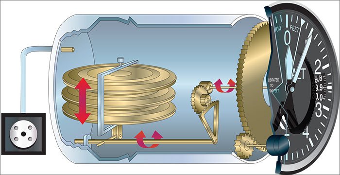
Astute readers will be wondering about the practicality of using QFE with a conventional altimeter. Today’s altimeters only have an adjustment range of around 28-31 inches of mercury. So, say it’s a standard day—29.92—and you’re on the ground at an airport at 1000 feet above sea level. Set to 29.92, your normal altimeter reads the field elevation, 1000 feet. If you want it to read zero, you’d have to turn the Kollsman adjustment down to 28.92. If you’re at an airport at 2000 feet, you’d have to turn the altimeter down to 27.92, and so on.
“But wait,” you say. “My altimeter can’t be adjusted below 28.10. That’s a problem.” This means that the highest airport where this QFE scheme will work is around 1820 feet. OK for a flatlander, but limiting for any serious flying.
One messy way to work with this is to mentally set a new “zero” point. Say you’re flying to Denver’s Rocky Mountain Metropolitan Airport, KBJC. The elevation is 5673. With a fully-capable QFE altimeter, when you’re at a stable altitude on the arrival, say 10,000 feet, you’d subtract the field elevation and set the difference. So, at 10,000 feet you’d set the QFE altimeter to read 4327 because that’s how high you are above the airport. The QFE altimeter will read zero on the ground.
But, if you can’t adjust your QFE altimeter that far, consider just ignoring the thousands. So, at 10,000 feet you’d subtract 673 and set the QFE altimeter to read 9327. Then, on the ground at KBJC it’ll read a nice round 5000 feet. That’s easy mental arithmetic. Easy, but still messy. It’d be nice to have an altimeter that actually could be properly adjusted.
So, armed with the conflicting information that we want an essentially infinitely adjustable altimeter while the altimeters in use today physically have stops that prevent them from being adjusted beyond the normal baro range, I went in search of the answer.
After getting the audible equivalent of the idunno head scratch and a blank thousand-mile stare from multiple well-regarded shops, I found one who knew exactly what we wanted.
In talking with John Dors, owner of Instrument Overhaul Service of San Diego (http://instrumentoverhaul.com), I barely got the initial description of what I was seeking out of my mouth before he interrupted, “Oh, you’re looking for an altimeter you can adjust to zero on the ground so you can use it like a poor-man’s radar altimeter. Yeah, I can build that.”
It turns out that, yes, indeed, altimeters used to work that way. Instead of having stops at the ends of the Kollsman scale, they simply pop up a mask over the window and allow you to continue adjusting ‘til the cows come home. Dors has been in business for a long time—so long that he’s looking to sell his shop and retire—and has collected a vast store of serviceable cores. He said he could easily take one of the older altimeters that work that way, and overhaul, calibrate, certify and sell it for $800.
So, although finding an altimeter that permits near-infinite adjustment is difficult, it’s not impossible. You’re just looking for a Kollsman altimeter with a mask instead of the stops and somebody who knows what that is. —FB
So, There I was…
Being in the moonless night sky above the middle of the North Atlantic at FL350 gives new meaning to the word dark, and a good definition of the word “quiet.”
Quiet, that is, except for the two Pratt and Whitney fanjet engines pushing our Boeing 767-300 along at 0.82 Mach toward London. Quiet, that is, until the radio tuned to the ship-to-ship common frequency suddenly announced
“Somebody just lost one at Guatemala City.” Everyone started asking “What airline?”, “Were there any fatalities”, “What happened?”
I frequently flew to Guatemala City. It was an interesting airport. (It’s bad form for an airline pilot to use words like “dangerous,” “hazardous” or “exciting.” If something was other than routine, it was simply “interesting”—our code word for a situation that created a pucker factor sufficient to instantly perform an inverted seat-cushion ingestion.)
So, Guatemala City airport was interesting. Its one runway was long enough, but was like landing in a saucer. The runway would drop away from you, then come up and smack you on the other side.
The south end had a sheer drop just off the end of the runway. People lived on the hillside below, and you could see the lights in their houses on approach at night.
Oh, and there was no glideslope landing to the north. There used to be one, but some airliner had made a sharp turn on the ground and the jetblast blew down the building housing the equipment. (It wasn’t me. I wasn’t there. You can’t prove a thing.)
We had a radar altimeter. But the steep drop off from the end of the runway and the uneven terrain along the approach path rendered the information it provided to be nearly useless.
We dealt with all that by programming the Flight Management System (FMS) to provide vertical navigation to the runway. But, one approach to that runway stands out in my memory. Both the FMSes failed—locked right up like a computer that knows you need it—leaving us with just the LOTW approach guidance system (Look Out The Window).
Fortunately, we also had QFE. The pilot’s altimeters would be set to read height above the airport when we descended through 10,000 feet and a third altimeter was set normally. By reading those altimeters, it was simple to know how high we were above the airport and to adjust our descent path so that we were able to touch down on speed, in the touchdown zone.
The crash? It was a Boeing 767 operated by a Costa Rican airline. The pilot was flying too fast, and he landed well beyond the touchdown zone on a wet runway. I don’t know if he had QFE available, but if he’d used it properly it might have helped him avoid at least the long landing.
He did one thing right however. When he realized that he wasn’t going to stop by the south end of the runway, he went off the side of the runway into the dirt—a far better resting place than down the cliff onto those houses.
A passenger was making a video out the left side of the aircraft as it floated half-way down the wet runway. Search YouTube for “Boeing 767 crash at Guatemala City.” There were no human fatalities, but the airplane died. The next time I landed at Guatemala City the wreckage was still there with the tail hastily painted over so you couldn’t tell the airline name. It was an ignoble end to a good aircraft—and a lesson to us all to carefully manage our height above the airport. —GS
George Shanks retired from a major U.S. airline, and now teaches for a major corporate pilot training center in Dallas. A QFE advocate, he doesn’t miss those arrivals into Guatemala City. The London pubs, on the other hand…


