Back when Southwest Airlines was the upstart operating out of airports “nearby” major cities rather than in them, everyone in New England knew about Manchester Airport (KMHT). They even call it the “Boston-Manchester Airport,” even though it was an hour’s drive away in a different state.
Now Southwest flies to Boston’s Logan Airport, and KMHT is more a sleepy reliever field. However, it’s still an aviation trendsetter, and this trend is open to anyone looking for more efficiency.
Mix and Match
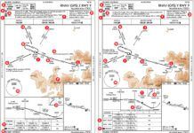
Check out the lower-left of the plan view on the ILS or LOC/DME Runway 17 approach. The IAF at PURBL is the beginning of a three-leg RNAV transition to BLUUM. (The approach designer must have sought homage to the haiku simplicity of self-guided approaches, hence the waypoints PURBL LYLAC BLSSM. He had to get creative as “PURPL” was taken, but they sound close enough if you’re not paying too close attention.)
PURBL has a mandatory crossing altitude of 5000, per the charted procedure, but this is only in the absence of any superseding altitude assignments from ATC. There’s also a maximum speed of 210 knots, which gets the same disclaimer. While we’re at this fix, note as well the “GPS REQD.” This is approach-level GPS, but not WAAS, so any /G aircraft can fly the segment. Because this route is the only feature of the approach requiring GPS, that’s where the sole note is.
And fly it you will if Runway 17 is in use and you’re approaching from the southeast (read: from any state except Maine). Controllers at Boston Approach love this procedure because it essentially replicates the vectors ATC would normally give, but all the wind correction and altitude assignments are handled by the pilot and the aircraft equipment. Non-GPS aircraft can be vectored in on essentially the same routes so the two kinds of traffic meld into a harmonious, Zen-like whole. There’s a similar three-leg RNAV segment to the ILS Runway 35, and a one-legger to the ILS Runway 6.
ATC can give you the approach right out of the ROZZE ONE arrival, as they share PURBL at 5000 feet as a fix. Or ATC can simply give you direct PURBL with an altitude to maintain until established, and your approach clearance.
Executing the approach from the pilot’s side shouldn’t be too complicated. Details vary with your equipment, but generally speaking, you should be able to load the ILS approach from PURBL and get GPS guidance on each leg. A tricky bit could be intercepting the localizer. Your system might automatically switch from GPS to localizer navigation, or might require a button push. It’s even possible your use of autopilot (or lack thereof) could influence the system behavior.
The takeaway is to watch it closely the first time you do one of these. “Your mileage may vary” is fine with your equipment, but not with lateral deviation from the localizer as you blast right through it.
You might ask why you’d make the transition from RNAV to ILS at all when there is an RNAV (GPS) Runway 17 approach with LPV minimums of 200 and a half, just like the ILS. In fact, the “purple lilac blossom” segment is lifted directly off the RNAV (GPS) approach plate. If you asked, then you’re bragging about your WAAS, because that’s the difference: With the combination, non-WAAS GPS aircraft get the best of both worlds.
Cut ‘Em Off at the FAF
Southwest still flies to Manchester, and these flights are still on the cutting edge of cost savings. However, this time it’s savings for the airline with the RNAV (RNP) Z Runway 17.
The approach shares both PURBL and the FAF at ORDIE with the ILS. (Yes, technically the ILS FAF is glideslope intercept and ORDIE is just the FAF for the localizer-only version. With that concession to our communal geekdom satisfied, let’s move on.) The difference between the approaches is a tighter transition that saves about three miles. Over time, that adds up.
Because this is an RNAV approach, GPS or equivalent is assumed. Yet this RNAV (RNP) explicitly requires GPS per the notes. That’s to fly the approach at all. The note by PURBL takes it a step further with “RF REQD,” which means this segment requires Radius-to-Fix capability. That’s the curved leg between FREEH and ORDIE. RF legs are the foundation of RNAV (RNP) approaches. The power of RF comes in that the leg is both a continuous turn and a descent, in this case from 3000 to 1600.
Practically speaking, a Southwest 737 on this approach would be in a continuous descent from FREEH through the turn and continuing down at essentially the same rate wings-level toward the runway. DAs are higher than the ILS or the RNAV (GPS) Runway 17 approach, despite the fact that the ILS, the RNAV (GPS) and the RNAV (RNP) all share the same FAF and final approach course. Ah, TERPS must have a few secrets revealed only to the illuminati entrusted with the deep secrets of approach requirements and varying obstacle surface areas. Suffice it to say, the RNP version won’t save time if you have to miss.
RNP is also not an option unless your equipment supports it and you have FAA authorization. The resulting mixing of approaches sometimes upsets a controller’s meditative calm bringing aircraft into Runway 17. For example, Southwest has authorization for this approach, but, as of this writing, FedEx does not. This is a problem when FedEx crosses PURBL on the transition to the ILS just ahead of Southwest looking for the RNP shortcut. Guess who loses?
Actually, the Boston controllers tell us it depends on speeds. Sometimes a slight extension for FedEx works out fine and saves Southwest reprogramming for a different approach. Other times, FedEx wins the toss. But no matter what, someone gets a vector to fix the problem. In the hands of a skilled controller, vectors can fix almost anything. You know, sort of like duct tape.
Keeping Up with Old School
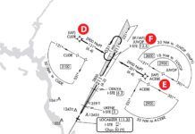
With all the fancy new stuff, it’s easy to overlook the seemingly old and familiar. Let’s suppose you do the GPS to ILS transition, but due to equipment issues on your end or theirs, you’re doing it localizer only. The missed is at DME 0.3 from I-MNA—but it’s the “other” DME 0.3.
Note in the profile view that you’ll cross the DME antenna, which means you watch it count down to zero. The MAP isn’t until it counts back up to 0.3. Given that the visibility for this approach is only 2400 feet and the runway is 9000 feet long, that could easily spell an unnecessary missed if you get it wrong.
RNAV is here to stay, and even capabilities like RF will eventually filter down to all fliers. Until then, watch for hybrids and combination solutions to put just a bit more capability into your hands when you’re piloting instead of hoping to get the A boarding group for that 737.
Jeff Van West enjoys any opportunity to make aging equipment do new tricks. He also fixes way too many things with duct tape.


