
Your trip to Florida wasn’t what you envisioned when launching from Texas that morning in clear skies. But what matters is you made it in safely despite things going wrong in the last 50 miles. Chalk it up to 1) a robust recurrent training regimen and 2) top-notch preflight planning, which had you collecting items you’d never think would matter. Turns out, all of that extra time spent prepping paid off in a big way on this trip.
Planning Simple
The Tampa Bay area is the destination, using Sarasota/Bradenton (KSRQ) for aircraft tiedown and a rental car. This’ll be a two-leg trip to include a fuel stop around Tallahassee. Wanting to avoid the busy airspace and ramp (and pricier fuel) at Tallahassee International, you filed to Quincy Muni (2J9) to the northwest. Cheaper self-serve fuel and a small but well-equipped FBO will do just fine for three of you to take a leisurely lunch break before continuing to KSRQ.
And you’ve already reviewed approaches, IFR routing, and the details about each airport, which was indeed overkill as VFR weather is forecast to prevail in the area. In fact, you don’t file an alternate (none’s required based on the weather) but will keep Tampa International in your pocket as Plan B.
The only significant weather is a Convective SIGMET in effect during the trip, covering western Florida and parts of southern Alabama. While an easy-to-see graphical overlay on a digital en-route chart shows you where the advisory area will travel, you like to take it a step further. Open up the SIGMET text for some additional detail that includes:
LINE TS 30 NM WIDE MOV FROM 25040KT. TOPS TO FL340.
The storms should continue shifting further east and pass Tallahassee by your ETA at Quincy. Looks good, but that’s definitely on the watch list. So you continue to work on routing to 2J9 and file:
MGM-V521-MAI-V198-SNEAD…with SNEAD identified using dual CDIs (your primary means of navigation backed up with a VFR GPS). The fix is on V198 and the 207-degree radial from PZD, the Pecan VOR/DME.
It’s also your preference to conduct thorough airport and NOTAM checks, especially for new destinations. Quincy’s definitely a local-use, mostly-VFR airport, and the notes on gliders and skydiving there give pause. Not only that, there’s just one approach, VOR/ DME-A, and it’s even NOTAMed “NA” until 2023 (possibly permanently; end dates are often placeholders implying “until further notice.”) Does this eliminate Quincy, besides the fact that you don’t have a DME or substitute? Not necessarily; with CAVU conditions expected outside of the storms, an early IFR cancellation at SNEAD or a visual approach would work. Besides, there are plenty of airports in the area that range from rather tiny all the way up to Tallahassee if Quincy won’t work.
On the Way…
Speaking of which, you’re glad to have brushed up on KTLH’s Class C in addition to the busy en-route airspace. You know, for instance, what the reverse-print, all-caps “MON” above Tallahassee’s airport identifier means. Those who don’t will first turn to the Chart User’s Guide, which says this is a “VOR Minimum Operational Network (MON) Airports Designator” to indicate that TLH has ILS and VOR approaches to use in case of a GPS outage. And: “Refer to the Aeronautical Information Manual (AIM) for expanded MON Airport guidance.”
The latter can be tricky to find in the massive AIM, but you did this homework well over a year ago. The rest of us will dig deep into Section 1, Navigation Aids: Scroll through 1-1-3, VORs, to Item f. There we find a lengthy (and somewhat repetitive) explanation that MON-designated airports are always within 100 NM at the most, and have “legacy ILS or VOR approaches” for aircraft with older equipment. (The best-read pilots know all about MON thanks to articles including “Are You Ready for MON?” in IFR, March 2020.)
It’s a perfect day with a tailwind to boot on the way to Florida, but nearing MAI and about 40 miles from Quincy, the buildups off to the south are clearly blooming, and while still moving northeast, might be sliding more towards Quincy than Tallahassee. You can bail out with a diversion request for TLH at any time.
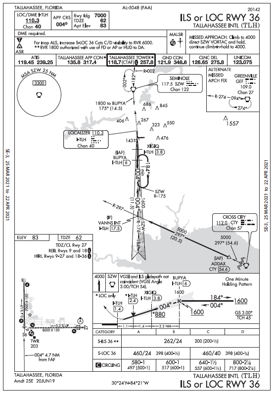
Good thing you also read up on NOTAMs there; the ILS system for Runway 27 is out of service, so for a backup approach to get you to the field ASAP, pull up the ILS or LOC 36. But then you remembered from a preliminary briefing a few days back: This approach chart has, in much tinier letters, “DME required,” which you don’t have (legally).
Examining the approach, you conclude that the DME requirement seems to be for the LOC only. So, you think you could fly the ILS, but no such distinction is on the chart. So, okay, in an emergency maybe, but what now?
One more IAP
Heavy rain pelts the airplane and suddenly you can’t see ahead too well. The associated noise and turbulence don’t help much either, so you ask for a beeline to Tallahassee. Of course, everyone else is thinking the same thing.
“Cleared present position direct BRITS. Hold at BRITS as published, maintain 3000, expect further clearance at 2020 Zulu.” Your extensive preflight briefings paid off and it doesn’t take but a minute to set it up: BRITS, reached on a course of about 165 degrees, is the intersection of the Marianna and Seminole VORTACs. You even recall that up to 6000 feet MSL, your maximum indicated holding speed is 200 knots (irrelevant to your light single) and the minimum for fixed-wing aircraft is 90 knots (surprised? See AIM 5-3-8). So you reduce power to hold at 110 knots, saving fuel.
Hoping the day can’t get much worse, the vacuum pump’s health becomes suspect, as shown by a slowly tilting artificial horizon.
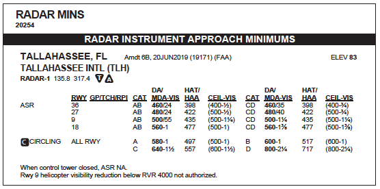
You remember noting that Tallahassee has Airport Surveillance Radar approaches, with Radar Instrument Approach Minimums in the Terminal Procedures publication. KTLH Runway 36, Categories A/B, have a DA/MDA of 460 feet … but no time now to review the particulars. You key the mic again and report the situation, requesting a no-gyro approach to 36. And you’d like a weather update ASAP to confirm you and ATC can execute the procedure (which does go down to 400-.).
And what good is any approach if you don’t know how to fly it? You always included partial panel and nogyro approaches in semi-annual recurrent training. So you even know from the IPH that ASR approaches have 250 feet of obstacle clearance and shallower-than-standard glidepaths “never exceeding 300 feet per mile.”
For those who might need a how-to guide, see AIM, Section 5-4-11, Arrivals: “The pilot should make all turns at standard rate and should execute the turn immediately upon receipt of instructions. For example, ‘Turn right,’ ‘Stop turn.’ When a surveillance or precision approach is made, the pilot will be advised after the aircraft has been turned onto final approach to make turns at half standard rate.” Your prior knowledge in all this, along with the airport weather holding at 2000-3 in light rain, made the approach a bit wet, but otherwise comfortable.
You belong to that small club who actually flew ASR approaches in training, instead of just talking about them. The rest of us would find practicing these educational and fun for us and ATC likes keeping current on these too. But they’re not required for either an IFR checkride or an IPC, and they’re getting rarer at radar facilities.
Meanwhile, aircraft owners are ripping out those old vacuum pumps and replacing them with more reliable and prettier electronic instruments. If you ever want to experience an ASR approach or see if you’ve maintained your hand-flying skills under the hood, head towards a TRACON that’s so equipped and make a request to practice one. It can take some hunting around, but it’s worth the extra time and is a great excuse to go fly for a while.


