
In WX SMARTS, rather than teaching weather safety, we put you at the forecast counter and immerse you in the preparation of TAFs, area forecasts, and advisories. In addition to knowledge gained, this allows you to select the tricks and techniques applying most to your flying. With November approaching, it’s a good time to review what changes we can expect.
Cooling Things Down
Let’s start with the basics. In the cool season the North Pole is pointed away from the sun. As the polar regions lose solar heating and the days shorten, the atmosphere cools significantly, and we see a huge semi-permanent polar air mass covering much of Canada and northern Russia. Parts of it break off regularly as frontal systems and polar highs. The large expansion of the cold air mass boots the jet stream out of Canada, pushing it down into the United States.
Landmasses absorb and radiate heat quickly. In the summertime the continents are hotter than the surrounding oceans, creating a (rising) heat-driven onshore component known as monsoonal flow, especially near desert areas. In the winter, this reverses and the continents become colder, dominated by high pressure. Because of this, low pressure areas over the continent in wintertime are always suspicious, and they’re very likely to connect with the jet stream to produce weather.
When there’s lots of cool air over the land mass, the inland highs drive a wind offshore. The Santa Ana winds are a prime example of this, occurring when very cold highs park over the Great Basin area and cause a dry northeast flow in places like Los Angeles. Along the Northeast and Southeast coasts, we see many days with cold northwest winds, producing extensive “lake effect” clouds offshore.
Fresh outbreaks of cold air spread across the eastern and central U.S. every few days, typically preceded by an Alberta Clipper or a Colorado low. Sometimes the cold air works its way into the Western states and gets trapped in valleys and basins. This can produce several days of IMC in places like the California San Joaquin Valley, Salt Lake City, Boise, and Alamosa.
Jet Streams
In winter, not only do we see a jet stream across the U.S. most days, but we also see the occasional appearance of the subtropical jet. If you fly airliners or corporate jets in the southern states, you’re probably familiar with this feature, most often found between FL350 and FL400, noticeably higher than the polar-front jet.
The subtropical jet isn’t directly associated with any fronts, but is maintained by upper-level temperature contrasts and conservation of angular momentum. Most of its weather is limited to lots of cirriform overcast and clear-air turbulence. The subtropical jet can dip into the tropical Pacific and carry the air northeast toward the U.S. This Pineapple Express is essentially a conveyor belt of moisture poured into the temperate latitudes.
Thus, the Pineapple Express can be a significant weather maker. When it’s pointed west, California gets flooding rains, and when it’s pointed east, it can interact with cold polar highs to produce snow, freezing rain, and lots of IMC. Deep southwesterly flight-level winds are a good sign that this might be happening.
Models Have Their Limits
Winter weather systems change quickly. Our understanding of weather systems is often incomplete when you get your briefing, and important changes evolve while you’re preparing for departure. Dynamical models have gotten quite sophisticated, but we’re still heavily dependent on limited weather observations.
With an average of only two radiosonde observations per state every 12 hours, we’re really counting on a single measurement of temperature and humidity, for example, in San Diego or Oakland to represent what’s happening 200 miles away in Bakersfield. The most sophisticated physics parameterizations are useless if there are data holes where things go undetected.
In computer parlance: “Garbage in, garbage out.” Unfortunately little is being done to fill in the upper air network with solid data, so TAFs, forecast products, and model data have varying degrees of inaccuracy for decades to come. If flying is your career or your primary hobby, a solid foundation in meteorology will pay you back many times over by helping you spot a problem early and knowing what to do.
Wind Tells the Full Picture
Wind and temperature readings yield vast amounts of information, especially in the winter. For example, take wind direction. This is related to stability. A northerly wind (in the northern hemisphere) usually means cold air is moving over warmer ground—a cold-over-warm scenario. For some of you who remember ground school, this means instability. The atmosphere will favor some degree of clearing, rising ceilings, VMC, and gusty winds.
Likewise, southerly winds mean warm air moving over cooler ground—a warm-over-cold. The risk increases substantially of cloudy weather, lowering ceilings, fog or haze, IMC, and weaker winds, along with the possibility of an inversion. These are the changes that might be coming next if there’s good VMC.
But this rule only applies if the terrain is uniform, such a wind that sweeps from Minnesota southeast to Illinois. If winds are coming off lakes and oceans, you instead have to consider the temperature of the water body. A northwest wind blowing across Lake Ontario into Rochester is quite often going to mean clouds and snow showers as it picks up warmth and moisture.
Icing 101
As we move into winter, ice becomes a big concern. Many of us think of reduced lift as a wing becomes coated with ice. But ice can also wedge itself into gaps and interfere with control surfaces. Ice can block pitot tubes and static ports, and accumulate on antennas, degrading communications.
We often think of ice as something that forms when the air temperature is below freezing. But that’s often not the case. Water molecules can’t make the transition from water to ice unless there’s a nucleus available, such as dust, pollen, an existing ice crystal, or even bacteria. So even if the temperature in the cloud is -12 degrees C, the air can be filled with trillions of liquid cloud droplets. We call this supercooled water.
At temperatures getting below -40, a nucleus isn’t required and water will spontaneously change to microscopic ice crystals. This type of ice is frozen in situ, and it doesn’t really adhere to the airplane. Flying on a 737 through cirrus, you’ll notice just a light frost on the wing that quickly goes away.
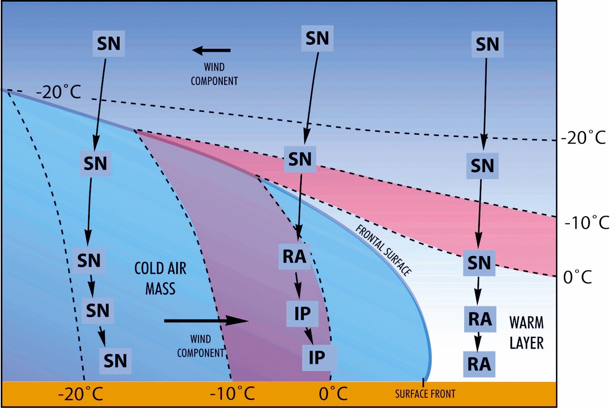
But at the warmest subfreezing temperatures, 0 to -10 degrees C, these ice crystals are nowhere to be found, and the atmosphere presents few other nuclei. Along come you and your airplane. Your plane helps serve as a giant traveling nucleus, meaning it’s party time for any supercooled water. Since it’s relatively warm, water freezes slowly, allowing the air bubbles to disperse, giving us clear icing.
At colder temperatures, below -10 to -15 degrees C, the water freezes faster, trapping the air bubbles and giving them a milky appearance we call rime icing. The colder it is, the less the moisture content, so ice coatings, especially in rime ice conditions, tend to not be as heavy.
Where It Comes From
Many sources traditionally point to cumuliform clouds as presenting the greatest icing risk, and indeed this is true of cumulonimbus and towering cumulus. But nimbostratus is also an effective ice producer. On the other hand, stratocumulus and fair weather cumulus clouds, which are all cumuliform, are not likely to produce much more than light icing because of the weak updraft strengths.
Cloud depth and especially precipitation intensity can be a much more effective indicator. If your destination is reporting heavy rain, that’s a signal that heavy icing might exist above the freezing level. To that end, weather radar is a good tool for this. If we look back on radar basics, we see that high reflectivity is caused by dense quantities of mixed water/ice phases.
Strong updrafts and ample low-level moisture are the best contributors to high reflectivity. A cloud that has high radar intensities at any level tells you there’s strong icing potential in the subfreezing portions.
There are also patterns that favor enhanced icing. Again if we consider high moisture quantities and a strong updraft, we find that the windward side of mountain ranges presents a locally enhanced icing hazard. The typical updraft speed in a warm front rain cloud is something like 20-30 fpm. But a 20-knot wind blowing up a 45-degree slope creates lift on the order of 1000 fpm. You can see how terrain is capable of creating a much more significant icing environment than we might otherwise expect.
At the large scale, we can relate our position to surface weather systems. The area just north and east of a frontal low is the most dangerous area for icing, because lift is maximized and tropical moisture tends to wrap into the system. And at the smaller scales, warm ocean currents and warm lakes can add plenty of concentrated moisture to the air mass. Again, this results in many more supercooled drops and enhanced icing problems.
Likewise the higher concentrations of moisture associated with the warm seasons means that the transition seasons of autumn and spring can be especially potent for icing. Even if temperatures are in the 50s on the ground, dewpoints in the 60s just to the south and an approaching weather system can mean lots of moderate-to-severe icing rapidly developing at flight altitudes.
What To Do About It
Once you’ve identified icing affecting your route, be sure to have an escape plan. In weather systems fed by tropical air, descending into above-freezing altitudes might provide the quickest option. In other situations, your airplane might allow you to get on top of the ice. And there are other situations where a course change is the best option. Knowing whether turning left or right will get you out of the icing the fastest is an ace card you’ll want to be carrying.
Area forecasts, weather briefings, and PIREPs are traditionally your best tools. And the principles and techniques we’ve just described will give you a sense of things to watch for. But there’s one more tool worth using: icing potential charts.
These charts have become especially important in the last 20 years as they take advantage of mesoscale dynamical models with parameterizations that simulate cloud processes. These techniques are quite new, they’re physics-based, and are very sophisticated. You can find these charts on the XM Weather broadcast to help you during your flight, and they’re also available at the Aviation Weather Center website. A good rule of thumb is if your route will be crossing through any fronts or major weather systems and you’ll be flying below FL250, you should check these charts to get a horizontal and vertical sense of where the trouble spots will be found.
These charts also offer information on the amount of supercooled large droplets (SLD). By definition these are supercooled droplets larger than 40 microns (0.04 mm) but they can actually be up to 100 times larger and carry more inertia as they spread over the top and back of the wing. This makes them especially dangerous. Cumuliform clouds, heavy precipitation, and high moisture are all efficient at producing SLD hazards.
The danger of SLDs was not well understood until the late 1980s. Until then they were regarded as rare, occurring in the worst storms. Then research aircraft began encountering them. Finally in 1994, an ATR-72 holding within a 0 to -5-degree C layer crashed near Roselawn, Indiana, killing 68. It galvanized aviation meteorology and led to new research into these phenomena. And 24 years later, you can instantly bring up forecast charts of where SLD conditions are most likely to be found. Now that’s progress.
And, Of Course, Turbulence
While summer brings some rather predictable forms of turbulence, with winter we see the entire spectrum. With the increase in mean wind speed nationwide, mechanical turbulence becomes an everyday hazard. Meanwhile clear air turbulence ramps up through the cool season, peaking in February.
Mechanical turbulence occurs due to strong low-level winds interacting with the terrain, producing strong vertical shear (gradients of wind speed). Instability is a key factor in chopping up the large-scale motions into small vortices that are quite effective at throwing an airplane around. Strong solar heating of the ground, or the movement of cold air over warm ground, are the two ways we get good low-level instability.
Clear air turbulence is mostly the result of sharp gradients of wind speed, both in the horizontal and especially in the vertical. An unstable atmosphere helps convert this gradient into motion. Weak instability shapes it into large waves, which an airplane can ride easily like swells on the ocean. But stronger instability breaks it up further into whirls and vortices, which is like the crashing of these waves. Strong heating, warm low-level temperatures, or cold upper-level conditions all enhance instability, along with perpendicular flow across mountain ranges.
Now you hopefully have a bit of a refresher on winter-weather basics and know what to look for when you start your flight planning. It all boils down to keeping tabs on the ingredients themselves and understanding how they’re all interconnected. In the next few issues we’ll go into more detail on some of the phenomena you might encounter, like snowstorms and frontal systems, and some of the tools you can use to track them. Stay safe!


