
You can fly a lot of IFR these days without encountering anything but GPS approaches with LPV minimums. In this challenge, you’ll fly departures and approaches at two airports where the procedures required are anything but standard. Better brief them well so the gotchas don’t getcha.
Use whatever airplane you like for this challenge, as long as it has a GPS. A WAAS GPS would be even better. Just be sure it’s something you can stay ahead of when things change in a hurry.
Kingston, New York (20N)
Start on the ramp at 20N. Set overcast ceilings at 600 feet AGL (750 MSL) with 1 SM visibility. Surface winds should be 210 at 12 knots, with winds aloft from 180 at 35 knots at 5000 feet.
Depart Runway 15 and fly the ODP to TRESA while climbing to 6000 feet. Then go direct to ILGEZ for the RNAV Runway 15. Land, and report back for debriefing.
Any gotchas on the ODP?
One trap might be remaining on the 153 heading for too long and flying through the PWL R-316. The procedure is not climb to 3000 via a 153 heading, then join the radial. It’s climb to 3000 via a 153 heading and the radial.
On the other hand, with the south wind you might not even intercept the radial before TRESA. When you see that’s happening—probably on the moving map—it’s reasonable to adjust your heading to the right to fly something closer to a 153-degree track instead.
Another mistake would be intercepting 316 radial outbound and going exactly the wrong direction, rather than setting its reciprocal and flying inbound. “Exactly wrong direction” is a surprisingly common error category, but it’s much less likely if the correct route is programmed in the GPS.
Create the leg you’ll join (CYPER-TRESA—see your low en-route chart) and activate it. Choosing direct TRESA on a 136-degree course is close, but not exactly right. That’s because the GPS will use the actual magnetic variation of the 136-degree course, while the VOR may not have been realigned in a while as the magnetic pole drifts. Not that anyone would notice or care about a possible few-degree error.
How did you get established on the approach at ILGEZ?
Were you surprised that the hold was missing from the GPS database? That’s because it’s not a hold in lieu of a procedure turn, HILPT. The non-bold depiction indicates an arrival hold. Arrival holds are simply commonly-assigned holds and not part of the mandatory approach procedure. You’d need ATC approval to use this one as a course reversal. In a GTN or similar modern GPS you could create the hold so the autopilot will fly it. Otherwise, use OBS mode and set the inbound holding course as you fly the entry to turn around. Either way, be sure to unsuspend before crossing ILGEZ inbound.
Did you see the runway?
The weather was barely good enough—if you knew where to look. The final approach course is offset 30-degrees from the runway (the max for an approach with straight-in minimums), so you had to look left. The right crosswind made this even worse.
However, there’s another reason you might not have seen a runway, depending on how you handled the vertical part…
Did you follow “+V” guidance? How low did you go?
This approach officially only has lateral guidance, with LP mins at best. But your GPS likely provided advisory vertical guidance. In nearly every case, best practice is to use that guidance. Remember that the LP minimum is an MDA, not a DA. That means you can’t dip even a foot below 720 feet. In order to fly this as if it were a precision approach, you need to start the transition to the missed before that—but the 600-foot ceiling doesn’t give you much room.
And there’s another problem: When established on the +V path at MDA, you’re about 1.5 NM from the touchdown zone. With 1 SM visibility you’re not likely to see it.
Alternatively, you could level off at 720 MSL and fly as far as the MAP to look for the runway. You could even ignore +V altogether and fly “dive-and-drive” style. But the closer you get to the runway, the steeper the descent required from the MDA, and it’s already a short runway. You might make it work, but it makes an already awkward approach a bit more treacherous.
A good briefing on any non-precision approach must include a landing strategy. That would’ve caught issues like these. You might’ve been wise to divert in real life, even with conditions (barely) above minimums. But this is the sim, so once you’ve made the no-go decision, you can still see how it would’ve played out.
Any other gotchas getcha?
With the ubiquity of cookie-cutter approaches today, a weird one can catch a pilot unprepared. And this is a weird approach in a bunch of ways, besides what we already mentioned. There are two bends—one at WOBVU and IMIBE, and then another to line up with the runway.
Also: How would you get the weather at Kingston? No frequency is listed and chart says you’re supposed to use the Hudson (KPOU) altimeter from 25 miles south. The airport METAR appears on most apps, but it lacks ceiling data. It turns out there is weather reporting at Kingston, but unless you use Jepp charts it’s sort of a local secret. The airport remarks in ForeFlight (but not the Chart Supplement) tell of a “SuperAWOS” that can be heard on the UNICOM frequency with 3 clicks of the mic.
Montague, California (KSIY)
Siskiyou has exactly two procedures: an ODP and an instrument approach. Both are built around the MOG NDB. Fortunately, you can use GPS on both of them. Set surface wind 360 at 5, with calm wind aloft. Set a 1400-foot overcast ceiling (4050 MSL) and 3 SM visibility. Siskiyou is within the PilotEdge ATC airspace, so fly it on network if you can.
Take off on Runway 35 and fly the ODP back to the MOG NDB. From there, you’re cleared for the NDB or GPS-A. Land, and debrief.
GPS is a valid substitute for the NDB on the departure, but how will you track outbound and inbound on an NDB bearing using a GPS?
It’s OBS mode for the win. Set a course of 356 for the outbound, and 176 back inbound.
Do you need to monitor a working ADF to fly the approach?
Nope! The “or GPS” in the title means that you can pick one or the other. For practically everyone who would fly this approach now, it’s simply a GPS approach, albeit one built around an NDB.
If it were named “NDB-A” instead, you could still use your GPS as primary navigation, but you’d need to display and monitor an actual, real-life ADF for at least the final segment. If your local museum won’t let you borrow one, you’re outta luck.
From 10,000 feet over the NDB, did you get down fast enough to join the approach?
You must remain within 10 NM of the NDB during the procedure turn. If you play it right, that gives you a maximum of 20 miles or so to lose 5200 feet by the FAF. That’s a doable 260 feet per mile. However, the GPS will prompt a procedure turn much earlier than that, so you’d need to either ignore it or descend even faster. Ignoring the GPS does work, at least on Garmin devices, which are smart enough to see what you’re doing and sequence at the right time.
You could also ask ATC for a couple laps around the missed approach hold to lose altitude instead. Conveniently, that’s on the protected side for the procedure turn too.

Did you land straight-in or circle?
There are no straight-in mins, but you can still land on Runway 35 with a straight-in approach. However, you’d need a descent of more than 800 feet per NM from the FAF, which is why no straight-in minimums are published. At 120 knots groundspeed, that equates to 1600 FPM.
That’s doable in the right airplane—it’s a 7000-foot runway after all—but might stretch the requirement in §91.175(c)(1) for a “…normal rate of descent using normal maneuvers…” Maybe it’s better to circle instead by entering an upwind for 35 and making an effectively normal traffic pattern, in what’s technically VFR conditions.
The trick is to keep your bearings as the runway slips below the cowl. The regs say you must keep the airport in sight throughout the circle, except if the airplane itself obscures it during maneuvering. You can boost your SA by not sequencing the GPS at the MAP. That way you’ll preserve an HSI and magenta line for quick orientation to the final approach course.
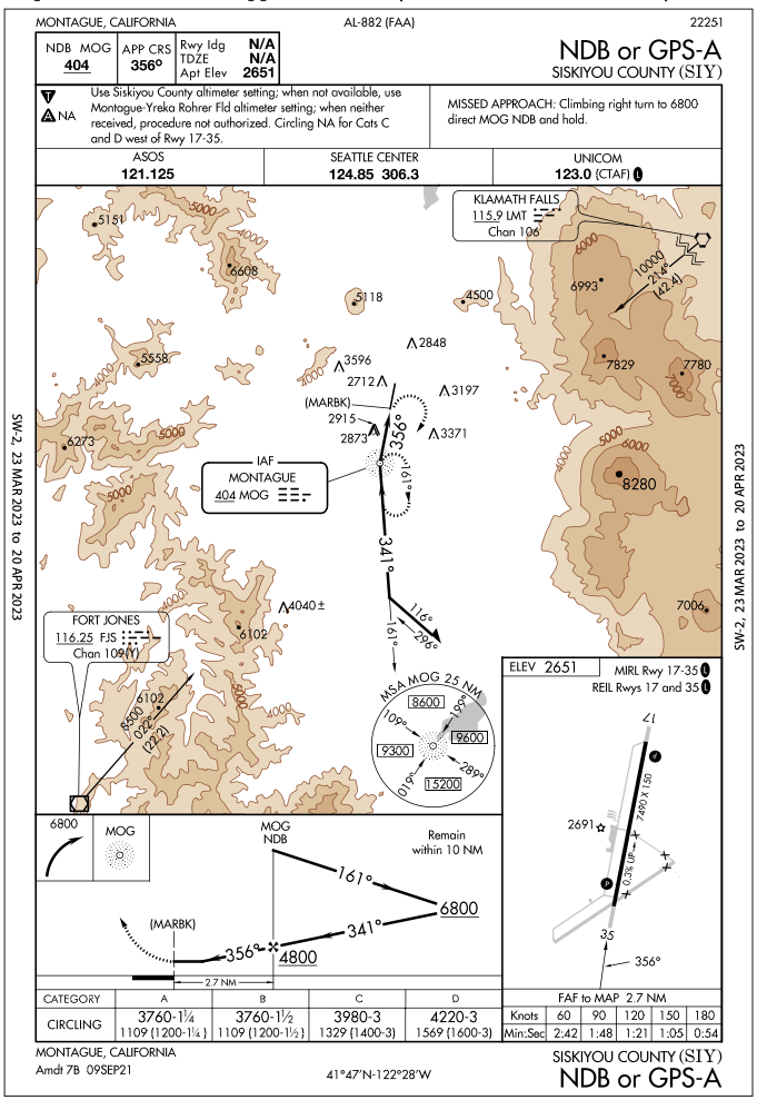
If you circled, what maximum circling radius were you protected within, and what direction did you turn?
If you’re a Category A or B airplane, you could’ve used 3760 MSL(1109 AGL) as the circling MDA, with a required 1¼ or 1½ SM visibility respectively. Or you could have elected to use the Category C minimum of 3980 MSL (1329 AGL), since the visibility meets the required 3 SM. That buys you a full 1.7 NM of protected circling area.
Note that the lack of a in the minimums section means this approach uses the old circling criteria. The new criteria would’ve protected 2.8 NM, probably with higher minimums as a result.
Any turns you made when circling should’ve been to the right, as that’s the published pattern for Runway 35, per the Chart Supplement or Sectional chart. Also something to check when your first brief the approach.
Ryan Koch and Jeff Van West both learned IFR when the 5Ts were a necessary skill. Maybe their enjoyment of turns at the FAF is nostalgia. Or maybe it’s just masochism.


I flew this sim approach (flytissim) using bonanza a36 profile. I found it difficult and it impressed several things on me.
The first was I missed the hold altitude and went to ilgez (iaf) at 3200 and did not execute pt at 5100. With 10deg flap approach speed too fast. I’m pretty good at looking at vertical decent required but did not prep it here. Thus I laminated the decent chart as its one thing not easily found in foreflight. The descents between all segments is aggressive, 800ft and if you get behind there is no easy way to make it up.
Finally if you break out at minimums the angle and final decent gradient are too much to land on a runway this short. Final note to myself be prepared to circle to land.
I very much enjoyed what looked like a simple approach, bonus I learned to fly nearby Kingston.