
Part of being able to forecast comes from reading the sky, because so much of what’s taking place in the atmosphere can be seen visually. When I worked the forecast counter in the Air Force, I occasionally stepped over to the window for a quick look while filling out the weather briefing forms. The pilots often caught notice of this. I remember one B-1B Lancer pilot who turned to his fellow crewmembers and said, “Now that’s what I like to see! This forecaster doesn’t miss anything.”
When taking in visual clues, forecasters look for signs of wind behavior, dust plumes, haze layers, patches of fog, unusual phenomena on the horizon, and the general appearance and color of the sky. But we most rely on the clouds and how they’re shaped and textured. When clouds are present there’s a lot of information at hand, and that’s what we’ll look at here.
There are ten basic cloud types: cumulus, stratus, cumulonimbus, stratocumulus, nimbostratus, altostratus, altocumulus, cirrus, cirrostratus, and cirrocumulus. You’re probably already at least passingly familiar with these, and FAA AC 00-6B, Aviation Weather, touches on these different categories. Rather than sorting out clouds individually, we’ll take a slightly different approach and break down some of the common skyscapes that pilots encounter while flying.
Fair-Weather Cumulus
The fair-weather cumulus sky is marked by weakly vertical cumulus clouds with flat bases and high layer altitudes during the afternoon. Fair weather cumulus are quite common during the summertime in moderately stable air masses, in other words, where the lapse rate is weak and the temperature doesn’t fall very much with height. Weak lapse rates are often associated with an upper-level high. On winds-aloft charts you may see an anticyclone, or anticyclonic flow. Conditions above 10-20,000 feet MSL may be a bit warmer than usual.
These highs are typically subtropical highs, such as those associated with the Bermuda High. As semi-permanent features, they’ll often park themselves over a region for weeks, giving the same weather day after day. On rare occasion the highs are cutoff highs, such as the one associated with the record-setting heat wave in the Pacific Northwest this past June. Those types of highs are much more short-lived, and after a few days, the weather reverts to more of a fastchanging, transitional pattern.
If lapse rates are steeper, instead of fair weather cumulus we get skies filled with moderate cumulus (MDT CU) and towering cumulus (TCU). These are the last stages before showers and thunderstorms. Lower cloud heights than would otherwise be expected, and bases that remain ragged and fail to flatten out over time, are good indicators that conditions are deteriorating.
Cumulonimbus
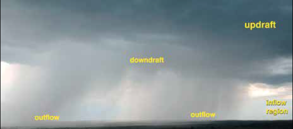
The cumulonimbus cloud is the ultimate form of deep convection, in which a cumulus cloud grows through much of the troposphere while maintaining both an inflow that feeds the updraft, and outflow produced by precipitation. The photo on the top-right of the next page shows what happens below the base of a cumulonimbus cloud.
Contrast this with a lot of photos you see on cloud charts showing the exterior of the cloud, with the ubiquitous anvil cloud crowning the top. However in the early stages of a cumulonimbus cloud, the anvil may not yet be fully formed, showing only a hint of glaciation, in other words, a fuzzy texture caused by the production of ice crystals.
If you can see the top of a cumulonimbus cloud, there are a lot of visual clues. The most important one is the crispness of the cloud tops. Nearly all storms with a powerful updraft contain a “rock hard” cumulonimbus tower, surrounded by glaciation or anvil material. This means that supercooled water has been rapidly lofted to high altitudes without much time for ice crystals to form. A “mushy” tower is a sign of a weak updraft, which implies the updraft material has had plenty of time to generate ice crystals due to slow ascent and long loiter times in the updraft.
Below the storm, it’s important to scan the cloud and identify all the key areas: the updraft, the downdraft, the outflow region, and the inflow region. The updraft can be identified easily because it makes up the bulk of the cumulonimbus cloud and shows dark base underneath. The downdraft tends to contain rain, hail, and in some cases, snow, and it almost always appears bright or flat grayish. This is because reflection and scattering processes are different since cloud droplets are replaced with large precipitation particles here.
The inflow can’t be seen but it tends to be free of rain, and you might see smoke plumes or cloud fragments feeding into the storm, or visual indicators like flags or wind socks pointing toward the storm. The opposite is true for outflow, and it often contains gusty winds and precipitation. The leading edge can be free of precipitation, and dust can be kicked up by the outflow. It may appear hazy or foggy due to condensation or the presence of very small raindrops. This is always a hazardous region for flying. All outflow should be assumed to contain strong wind shear close to the ground.
Altocumulus Layers
Altocumulus is a middle cloud, technically between 6500 and 20,000 feet AGL, which is not completely stratified and contains textures that can be classified as rows, bands, or individual cloud elements. Its counterpart, altostratus, is almost featureless, shows no distinct cloud elements, and is spread out horizontally in great swaths across the sky. You’ll rarely see it except near frontal systems close to rain and snow areas.
Lower middle-clouds like the altocumulus shown typically boil down to one of two causes: forced ascent of mildly unstable air, such as around frontal systems, or convective debris from storms in the past 24 hours. This photograph was the latter: thunderstorm debris from New Mexico the previous evening had drifted into Texas. On rare occasion when there’s a very strong mid-level inversion, altocumulus will form when cumulus clouds rise and spread out.
One type of altocumulus cloud deserves special note: altocumulus castellanus, which we used to see in METAR reports (back when humans were at all the weather stations) as the abbreviation “ACCAS.” This cloud type looks like miniature cumulus towers. It’s a good sign there is strong mid-level instability. In the morning, it can be an indicator of thunderstorms later in the day.
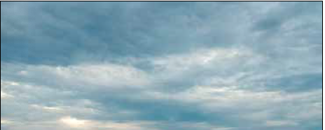
Overall, altocumulus won’t affect your flying activities very much. You might get a little light chop and some light rime icing within them. However since some of these layers are associated with frontal systems and frontogenesis, especially during the cold season, it’s still important to check TAFs and make sure things will remain VMC.
Cirrus Clouds
You’ve probably seen cirrus clouds so often that you don’t pay them much attention, but they do provide useful clues. The first thing to do is differentiate whether you’re looking at dynamic lift or convective debris. If it’s summertime and winds aloft are light, it’s likely convective debris, that is, icy moisture from the remnants of a storm during the past 24-48 hours. It’s quite possible these storms didn’t happen where you are, but occurred elsewhere in your region, perhaps hundreds of miles distant.
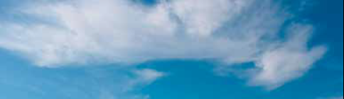
If you’ve ruled out showers and thunderstorms, or if you’re in the depths of the cold season, you can assume the clouds are occurring from dynamic lift. This lift is often, but not always, associated with a jet stream. With cirrus from dynamic lift, it’s important to track the trends. A decrease in cirrus over time signifies improving weather, while an increase in cirrus strongly suggests deteriorating conditions, hence the old sailors’ warning about “mare’s tails” invading the sky. This rule does not hold true for convective debris, however, which is basically a dumping ground of moisture in the sky and could evolve either way.
One special case of cirrus bears mention: cirrostratus. Not all weather photo galleries get this one right. The key is to look for a veil or a uniform blanket that covers most of the sky. Halo phenomena are very prominent with cirrostratus, and you may spot sundogs on either side of the sun. Cirrostratus is an indicator of vast amounts of upper-level moisture and large-scale lift working on the atmosphere. If this lift continues, deteriorating weather will follow. If cirrostratus further develops into overcast altostratus, you could be looking at moderate to severe icing risks rapidly developing, with extensive precipitation later on with continued lift. This type of sky is usually found poleward of an approaching warm front.
Cold Advection Stratocumulus
Stratocumulus clouds typically exhibit two unique attributes: a ragged uneven base, along with good visibility below, allowing you to see a distant horizon. Expect low-level turbulence.
The situation usually occurs behind a fast-moving cold front. Much colder air sweeps in behind the front, and temperatures through the atmospheric column are falling. However heat from the ground continues to conduct into the bottom of the air mass, producing very steep lapse rates in the lowest thousand feet. This causes thermals and overturning of the air from the surface up to the cloud base. The ragged base is a telltale sign that this mixing process is still occurring.
As dry air filters in, the clouds often begin dissipating. However if strong solar heating begins working on the ground, especially if conditions are damp, this can cause overcast clouds to redevelop as a new round of destabilization takes place. Deep upper-level lows sometimes follow in the wake of frontal systems, and these can be associated with rain and snow showers, and sometimes even low-topped thunderstorms. This activity subsides by sunset as heating diminishes.
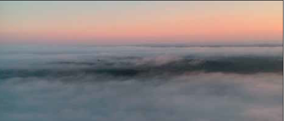
Stratus and Fog
Stratus and fog are definitely recognizable as culprits when an airfield is socked in. They’re actually somewhat interchangeable. For example, when classic radiation fog “lifts” it becomes stratus, appearing as a gray featureless mass hanging low above the ground, but sometimes as high as 2000 feet or more. However, if strong solar heating begins working on the earth’s surface, this layer will rapidly transition to a layer of very low cumulus clouds and the bases will gradually rise as heating continues.
There are a couple of ways these clouds can form. Radiational cooling, especially over moist ground under a clear sky, allows for the formation of classic fog. This is what is seen in the photo. Radiation fog can lift into low stratus if winds are above 10-15 knots, due to atmospheric mixing. Advection fog and stratus occur when a moist air mass advances over a cold surface, forcing condensation. This is common during the transition seasons, especially in the southeast United States. Finally, these clouds occasionally form as “scud” when precipitation is occurring close by.
Closing words
Besides just observing the clouds, trends in layer heights, confirmed either visually or in METAR reports, are useful for identifying improving or deteriorating conditions. This is true not only for fog and stratus, but for all cloud types. This can be helpful when you have only a single reporting station to work with. It’s important to consider that daytime solar heating naturally causes cloud layers to rise and nighttime cooling causes them to fall, so trends that run against the grain are especially significant.


Good reminder. Thank you