
It’s the writer in me that can’t resist playing with words. That’s why I can’t decide if this clinic’s title should be as you read it or, “Missed, the Memo,” as in a long treatise about the missed approach. Because that’s what’s odd here, and I’ll admit I didn’t see it until someone else waved the WTF flag.
It started with an email question: How do you identify SWASO on the missed approach at Knoxville Downtown Island (KDKX) LOC RWY 26 approach? A quick glance says, “Duh, it’s an intersection,” but a closer inspection says it’s not that simple. The identification of SWASO on this approach chart omits a few critical details—enough that if you still don’t have an IFR GPS, you might find yourself at a loss.
Required Equipment
Start with the note in the plan view that says, “DME or RADAR Required.” (Not to be confused with the note saying, “ADF or DME Required,” which we’ll talk about later.) This says we need DME or ATC radar to transition from the en-route environment to the approach. There’s only one IAF, at AUBRY. AUBRY is on V136, so getting there requires only a VOR. But getting from AUBRY to the localizer requires a DME arc, which is pretty dependent on a DME receiver or a GPS in its place.
You can also lean on ATC to vector you onto the localizer. No surprise there. However, you can keep leaning on ATC for virtually the entire approach. Note the word “RADAR” for SPROC, RIZEN, and even the stepdown fix at WOGEL. You see it in both the plan view and the profile view. This means you can count on a controller to call crossing each one of these fixes for you, so long as you ask for the service in advance.
It’s unusual for a stepdown inside the FAF to have this RADAR badge, because you’re pretty low by this point. That matters as this is a dual-minimum approach. There’s an MDA if you can identify WOGEL (1460 MSL) and an MDA if you can’t (1820 MSL). There’s also an MDA of 1880 MSL if you can’t get the local altimeter, as noted by the asterisk note in the profile view.
So, you can stepdown all the way to the lowest MDA without any equipment beyond a single nav receiver for the localizer. The missed approach point can be identified by timing, as shown by the timing table under the airport diagram. This is really a throwback, as anyone with an IFR GPS will identify it by the RW26 waypoint in the GPS database. But if you don’t have a GPS, you start a timer when you cross RIZEN, do some quick mental math to estimate your groundspeed, and go missed approach after the right number of minutes and seconds go by. (It’s rather amazing more airplanes didn’t turn into compressed metal performance art using the timing system.)
Taken all together, you can fly this approach from the en route environment to DA with one nav, one com, and a transponder. I dare you to try that on your next IPC.
The Missed … with Missing Info
If you don’t need “DME or ADF” for the approach itself, then, the note requiring one of them must apply to the missed approach procedure. (Published missed approaches may not rely on radar.) This missed requires flying a heading of 250 to intercept the 265 radial from the Volunteer VOR. Fly to SWASO and hold.
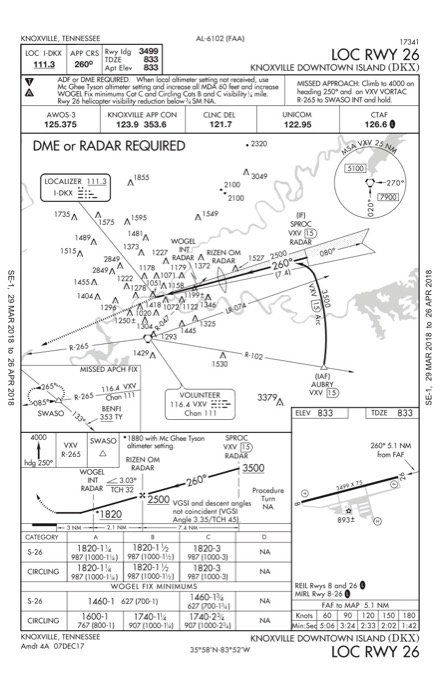
And there’s the catch: how far from Volunteer is SWASO? The approach chart doesn’t say what the DME distance is. You’d think that would be important information. It’s important enough that Jepp users get the number on the approach chart. It’s 18 DME from VXV.
Government chart users don’t see it because SWASO is on the en-route chart. The Oke City charting gurus figure, “Why tell you twice?” Maybe they figure if you’re using DME for primary nav you’ll have a yellowing paper L-25 chart doubling as a sun visor on VFR days, so the reference is close at hand.
So much for the DME mystery. How do you identify SWASO with ADF? Well, SWASO is an intersection with R-265 from Volunteer and a bearing of 133 to BENFI. BENFI’s frequency is 353 with an ident of TY. That’s clearly an NDB. Published NDB bearings are always to the station, so BENFI is somewhere to the southeast of SWASO. We’ll just find that on the old L-25 chart … or not.
Go ahead. Find BENFI. I’ll wait.
If you have a tablet or GPS you can type in BENFI and you’ll get a waypoint that’s still in the government database. It appears in the middle of nowhere, with “nowhere” being defined as southwest of Knoxville’s main airport Mc Ghee Tyson (KTYS). Hmm. The most logical answer is BENFI is a localizer outer marker (LOM) on an ILS approach to KTYS.
Call up the approaches to KTYS and you’ll be rewarded—almost. There’s BENFI. It’s an IAF and the FAF. It’s an outer marker (OM), but it’s not a LOM. The difference is the NDB station. An LOM is both a fan marker, which makes the “O” on your audio panel flash and the steady “boop-boop-boop” in your headset as you pass overhead; and an NDB station, co-located.
The approach chart for the ILS or LOC Runway 05L just says OM. There’s no co-located NDB. You can’t navigate direct to a fan marker, nor can you determine the 133 bearing to using an ADF receiver in the airplane.
Keeping Up with the Times
The mystery resolves when you look at the Hi-ILS or Loc Runway 05L approach for KTYS. Hi-ILS approaches were designed for century-series military jets that burn such ludicrous amounts of fuel at sea level they were minimum fuel on takeoff. Hi-ILS approaches let them stay in the thin air as long as possible by intentionally creating a slam dunk to the glideslope. The lowest approach category is C and the minimums go all the way to E. Category E means an approach speed of 166 knots minimum.
The Hi-ILS shows BENFI as an LOM, complete with the frequency of 353 and an ID of TY. Unfortunately, it also has an amendment date of June 15, 2015 (look in the lower left of the approach chart). The ILS or Loc Runway 05L at KTYS, which charts BENFI as just an OM, has an amendment date of March 02, 2017.
Apparently, between 2015 and 2017 the NDB station at BENFI was decommissioned. The GA approach was updated to reflect this, but the Hi-ILS Rwy 05L at KTYS—and the Loc Rwy 26 at KDKX—were left in the lurch. So was any pilot who might fly the Loc Rwy 26 approach with a real ADF rather than an IFR GPS.
Luckily, neither of them has been to Knoxville in the past few years.
Brief It Through the Missed
It’s also possible that the NDB at BENFI is still there and the newer chart is wrong. But that’s less likely given that LOMs are becoming the stuff of aviation lore and transportation museums. The takeaway for all of us still trolling around the system with mismatched avionics spanning decades of technological prowess is to read all the notes and check all the frequencies before trusting our skins to the system.
Sometimes someone in the great machinery of data distribution misses the memo.


