
First, the FAA decommissioned 479 NDB procedures in 2005, saving around $8 million a year. The under-300 associated stations owned by the FAA were far beyond their planned 20-year service lives. Then they implemented the VOR Minimum Operational Network (MON) Program to retask and reshape Victor airways into a downsized backup network should GPS fail. That plan will decommission 311 VORs by 2025.
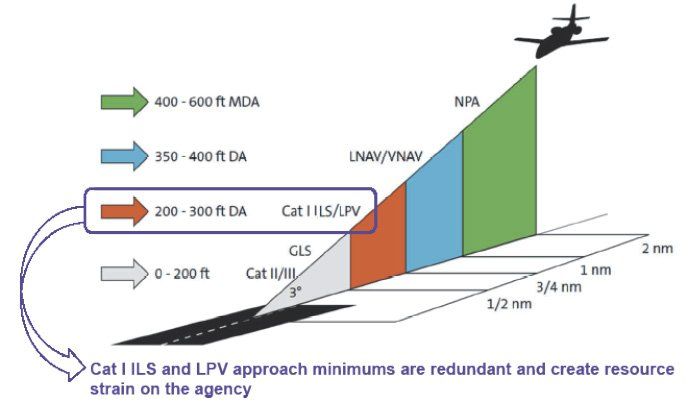
The FAA wants as many approaches with vertical guidance as possible. Statistics show that a pilot is four times more likely to have a CFIT accident flying a non-precision approach than one offering vertical guidance. Having trimmed the low-hanging fruit, the FAA is looking at the Sacred Cow, the ILS.
First deployed in 1938, the ILS has become the global gold standard of instrument approaches. There are 1550 Category I ILS approaches in the U.S. at this writing. About 1700 localizer-only procedures are also on the block.
The number of ILS approaches remained steady since WAAS begat LPV approaches in 2003. The graph below shows a flat line for ILS approaches, whereas LPVs have risen dramatically. Today’s 4476 LPVs outnumber ILS approaches by nearly 3:1.
About ILS
More than 70 percent of the ILS equipment is beyond its 20-year service life. Most are Thales Air Traffic Management (TATM) Mark 20A’s, the only certified unit until 2005 when the FAA contracted with TATM to develop a new version. In 2014 the FAA ordered five new ILS-420s, under a new five-year contract.
The contract won’t add more systems, but will replace systems damaged or broken beyond repair. About five new systems per year are needed. The FAA must justify each one by a cost-benefit analysis. For example, sustainment expenditures are calculated to last 20-30 years from the last swap date for each ILS considered.
The Case for LPVs
An LPV is a software construct. It’s not free, but it’s much less expensive than an ILS. An LPV is a one-time expense plus a minimal cost to manage it. As an FAA engineer told me, “It’s all in the math.”
Perhaps its greatest virtue is that it makes possible high-quality vertically guided approaches at thousands of airports where an ILS is too pricey. LPVs make it possible for smaller and especially remote communities to receive reliable air service and help knit those communities into the air transportation fabric.
FAA Flight Standards is updating Terminal En-Route Procedures (TERPs) to allow additional runways to qualify for LPVs, bringing vertically guided approach services to more airports.
GPS approaches evade all the expenses that plague a ground-based navaid. An ILS has a high initial cost with its accessories and critically, antennas. An airport must allocate real estate. Someone must appropriately site each component and provide for power. The system, especially the antennas, constitute surface obstructions near a runway.
Virtual approaches have no depreciation, need no power (or backup), have no operation or on-site maintenance expenses that lengthen downtime. There is no expensive two-year mandatory flight inspection since only ground-based navaids are flight inspected.
The DoD and the FAA centrally monitor GPS and WAAS, respectively. Indirectly they watch all LPVs, obviating the need for costly remote control and monitoring of all ILS equipment. Should an ILS component fail, it flags us in 8-12 seconds. An LPV flags in 6.2 seconds or less.
ILS vs. LPV
We rarely consider the adverse attributes of ILS because we uncritically accept its shortcomings as “it is what it is.” Take a fresh look, and you can see all the extra care and caution an ILS requires compared to an LPV.
Operationally, there is no problem with active LPVs at both ends of a runway, whereas an ILS cannot be used simultaneously at both ends due to possible interference. Nor is there a back course localizer and its awkward away-from-the-needle correction. Gone is the detritus of a bygone era: dashes and dots, compass locators, and marker beacons, to name a few.
All the ILS course distortions we live with vanish when there is no signal to distort. False glideslope signals on either a localizer back course or a front course approaching glidepath intercept cannot occur on an LPV. ILS occasionally fools pilots with bogus courses and reverse sensing at angles well above the published glidepath.
Nor is there an ILS critical area when the weather is below 800-2. No more do we have to cope with unmonitored critical areas at nontowered airports where vehicular traffic could cause needles to wobble and the autopilot to deviate if flying a coupled approach.
LPV approaches provide range information natively. But an ILS requires a low-power DME, and not all are so equipped—nor are many GA aircraft.
A point favoring ILS is that if the glideslope fails, the pilot can sometimes opt for the localizer approach. With an LPV, it’s all or nothing.
Pilots get the message. LPVs are designed to fly like an ILS. If there is a choice between the ILS and the LPV, more and more of us opt for the LPV.
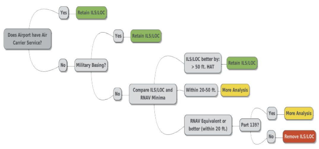
“Rationalizing” ILS
In 2015, the FAA began looking to “rationalize” ILS approaches. In this context, “rationalize” means “cut.” The following year, the FAA developed a cost/benefit quantitative model and conducted an analysis at about 2900 airports with few or no RNAV SIDs or STARs. The finished product was a plan to decommission Cat I ILS approaches at some of these airports between 2020-2030. Before a decision was reached, the project was shelved in 2017.
Early in 2019, plans were drawn to restart the program with a strategy decision late that year. As of mid-December 2019, there was no public announcement. Once announced, it will appear in the Federal Register for comments and feedback. The FAA says that discussions with stakeholders will be critical. Timewise, site identification could start this year and might extend beyond 2032 as larger airports are “rationalized.”
The FAA said in early 2019 that ILS approaches could even be discontinued this year. But the longer it takes the FAA to make its decision, publish it, evaluate comments and respond, the later cutting can begin.
The 132 ILS approaches in the VOR Minimum Operational Network will remain until a seamless NextGen replacement is flightworthy. Development, let alone deployment, won’t even begin until 2026-2030. MON ILS approaches will be with us for a long time.
No personnel or training costs impede ILS rationalization. Considerations for operator costs, monetized safety impacts, FAA Operation and Maintenance, and sustainment costs remain.
The scope of the project includes rationalizing ILS only at airports where an LPV approach provides redundancy. ATC keeps a record of approaches flown under IFR, but not practice approaches. The FAA can decommission an ILS if it turns out that the LPV is the primary approach in use. No vertical guidance will be lost, as that would be contrary to the FAA’s goal of adding approaches with vertical guidance.
Before rationalization halted in 2017, the FAA analyzed 402 ILS/LOC approaches at GA airports. The estimate for removal ranged from 167 to 292. Total savings would be $246M to $430M, respectively, over 20 years.
There will be no wholesale shutdown of ILS approaches in the foreseeable future. The numbers imply that if enough pilots fly LPVs, the LPV could move from being secondary to the ILS to become the primary approach, and the ILS would become, well, redundant.
To give you an idea of annual traffic volumes needed for retention, analysis of these 402 approaches called for 6200-plus flights using an ILS to be worth keeping. The possibly retained ILS approaches required about 2000, and the removal zone was around 1400. Perhaps this means that if we want to save an ILS, then we must fly it more—under IFR if we want it to count.
The numbers drill down to estimate whose ox gets gored. If the FAA removes an ILS and 25 percent of users lose vertical guidance, that speaks strongly in favor of keeping it. The FAA might retain the ILS if 21 percent lose the horizontal needle, a considerable difference for only a few percent. In the remove category, only eight percent would lose out.
This Dog
The attractiveness of ILS lies in the relative economy of its equipment costs, and its pervasive worldwide endorsement. Advances in technology over many years have yielded significant improvements in accuracy, dependability, and maintainability. The fact that ultra-precise ILS Cat II and III approaches use essentially the same system is a tribute to its sturdy simplicity and the genius of its designers.
Even so, this dog has had its day. The operational and financial benefits of LPV are compelling. The FAA will likely cut 200-plus ILS approaches over the next five years. After more than 80 years of robust service, it’s the beginning of the end for ILS.
Fred Simonds, CFII, has gone over to the dark side and now cherishes those newfangled LPVs.


Eliminating ILS approaches will leave pilots in IFR conditions and their passengers vulnerable in the event of either a military GPS jamming exercise or a GPS-related system failure in the cockpit. In the aircraft, ILS depends only on the (usually redundant) NAV receivers, and if the ILS system at the primary destination airport fails, it’s easy to find an alternate with ILS. Given the size of the Federal budget, and how much Congress is willing to take on billions in debt to save lives during the pandemic, it would seem that saving $10-$20 million per year by eliminating ILS approaches would be a truly penny-wise and pound-foolish decision by the FAA.
Spot on. The satellites are Achilles heel of the GPS system.
Since this article was published, I (Fred) learned this rationalization project has again been tabled, this time indefinitely. It will probably never be resurrected because the will to do it doesn’t seem to exist. It’s nickels and dimes, as many commenters have pointed out, and high risk, low reward.
Thank you all for your thoughtful comments. I always appreciate our readers’ perspectives.
-Fred S.
The Chinese have already developed, tested and have ready for use, satellite killers. When they invade Taiwan in the next few weeks or so, according to intelligence reports, we will learn of the invasion when they take out our satellites over the Pacific.
All well and good BUT tell the government to STOP the seemingly constant GPS interference “testing” otherwise keep the ground-based ILS.
Also, what about SEL emergency operations…With an engine out the ILS can provide a way all the way to the ground in 0-0 ceiling and visibility. My chief flight instructor made me do this during a stage check during my instrument training. You hope it never happens but it could. I think about this and practice this emergency scenario at least once a month in the sim. But, if I fly LPV it flags at the missed and proceeds to the missed. Maybe it’s a sim-ism but I don’t think so.
According to the diagram it looks like the only way you can do this is with GLS (and probably great expense). And would an avionics shop even install one? I don’t think eliminating ILS is a good idea.
All this amounts to is a continuation of relieving burden and liability on the FAA and putting it on the airplane owner. It talks about the financial benefits, but that’s for the FAA. These systems are expensive and hard to justify for an old, light aircraft. But thank goodness as pilots we are rich and this isn’t a problem. such is the way of all things in the world 🙂
Okay, but be aware that only glide paths with no published DH are usable to the runway.
Otherwise, the threshold signal is considered accurate down to the lowest decision height (DH) published on an ILS approach procedure.
Any reference to glide-path indications below that height is supplemented by visual reference to the runway environment.
Best,
~Fred
Part of the reason for keeping ground-based navaids was to protect against loss of GPS either by an aircraft or worse, through accidental or intentional interference…especially in poor weather conditions where precision approaches are needed. FAA occasionally gets into money-first mode and starts cutting backups because, well, they don’t get used that much. True, but when you need them, you need them. At one point during GPS introduction into the system, FAA was considering GPS navigation, GPS-based surveillance (get rid of those annoying radars…), and time-division multiple access radios to increase communications capacity – with the time coming from GPS. So if GPS packs up, you don’t know where you are, ATC doesn’t know where you are, and you can’t talk to each other, either.
But it’s cheaper!
The very idea of trying to save money is laughable. What savings the FAA might realize pales to an insignificant pittance next to the appalling trillions gratuitously squandered by a self-indulgent Congress.
With outrageous expenditures going to ridiculous— even inexcusable— causes under the guise of Covid stimulation, why shouldn’t our tried-and-true ground-based navaids and procedures be left unmolested, serving the country’s transportation needs while continuing to employ those who maintain them?
Spot on John! See my comment below. Congress wastes money on garbage that has no benefit to general public but then wants to cut costs on something, (transportation), that provides value to all citizens. is that not the definition of insanity? That’s what we have running the country…
I have flown several approaches in the Sacramento area lately where an LPV approach degraded to the point where I had to fly step-downs . . . in 2 different planes. In practice, I am finding that ILS approaches are more reliable.
I am also concerned that LPV is not considered a precision approach for the purpose of selecting an alternate:
“When standard alternate minimums apply, since ILS is a precision approach a 600 foot ceiling is required at the alternate, whereas since LPV is not considered a precision approach, an 800 foot ceiling is required. ”
(from https://www.ifr-magazine.com/system/comparing-lpv-and-ils/)
I fly technically advanced aircraft and would be happy to use LPV approaches if they were as reliable as ILSs and if LPV did not force higher alternate minimums.
I was out with a buddy last night practicing approaches. I was PIC, he was SP. We were headed to KAHN in eastern Georgia and being vectored for the RNAV-RWY-9 approach. We have Garmin 430W so briefed for an LPV approach. As we neared the IAF, the GPS never switched to LPV but stayed on LNAV. The flashing message reveled degraded service and hat LPV not available so I flew the approach as LNAV and had to quickly re-brief the approach and step downs. My point here is, GPS is great but I think a mistake to get completely rid of ground based navigational approaches. Obviously the getting rid of the NDB made complete sense, but ditching ILS approaches in favor of all GPS is a mistake and a could pose a big problem in event of a major outage or interference that impacts a wide geographic part of the country. I laugh at he FAA saving a few million dollars when our pathetic leaders want to spend $86 million on hotels for illegal immigrants which is a problem they created. Sorry, did not want to be political but it’s all connected in government.
Around 10 years ago the NSA released an unclassified study of GPS vulnerabilities. Yep, that expensive constellatiion of orbiting satellites has several foreseeable sources of limited or total failure. Yes, there are internal instrument errors to the orbiting packages, also periodic testing to assure all is well in the heavens. Then, there are several potentially hostile countries with the capability of local or wide spread jamming. We should remember that China is actively testing satellite killers, so easily remediable jamming might be the least cost (to us) in a serious conflict. Finally, we have sunspots that periodically intensify. The idea that there are no maintenance or replacement costs for individual units of the satellite constellation is ludicrous. At the moment DOD picks up a huge chunk of that cost. It’s only a matter of a few more Trillion Dollar “think Big” bailouts and someone will suggest that “user fees” be levied on agencies and companies that benefit from those expensive hunks of technology. Just wait… it’s coming.
Simply stated this looks like it is something which looks good to an MBA in some office, but not so good to a PIC on a stormy approach and the satellite constellation goes into interference testing or some other failure. How do we measure lost lives in those “saved” dollars?
As a CFI I am shocked to hear so many pilots expressing concern over a failure of the brilliantly designed GPS / WAAS system(s) that are beginning to dominate our navigation system. The very thought that some software designed by human hand (and probably at the lowest cost bid available) could fail shakes my faith in mankind. Sure there are the occasional loss of RAIM, and the periodic intentional outages, and there is that data base that might not get updated now and again. But, hey, don’t you think the FAA (as a part of the great federal government) knows best. After all, didn’t they get all over Boeing (after they let Boeing do it’s own system verification on the 737 Max) – I’m grateful that we have the good ol’ FAA watching out for our safety and making these decisions that will certainly keep us all safe.
The GPS “signal” is transmitted on known frequencies at very low power–easily jammable by battery powered
jamming transmitters. It seems to be a system just waiting for several jamming transmitters hidden at critical
locations and timed to begin transmitting simultaneously, or staggered times to complicate locating and disabling the transmitters. I believe it is foolish to pretend some of our less friendly “neighbors” on this planet have not considered the pandemonium such an act would create.
In aviation redundancy is a safety feature. Putting all our “eggs” in the GPS basket, is not going to enhance safety. As others have pointed out, GPS is not 100% reliable, and to be honest, no system is. Having an alternate option enhances safety. Having an ILS runway, within 100NM isn’t much of a safety feature either, especially for an SEL GA pilot. If the GPS failure is in the Aircraft, he maybe ok, if he has fuel, etc. If it’s a system wide failure, imagine if all the IFR traffic in a region was being directed to one or two nonGPS based approaches, trying to follow limited VOR guidance, and with pilots who’re probably not practiced, having been using GPS exclusive?
Run a few What If scenario’s, it gets pretty interesting.
I teach, always have an exit strategy, have a backup, a way out. Done be forced into a single course of action, because at that point, your options for a good outcome are highly limited. Apparently the FAA feels that redundancy is not a good safety feature, if its too expensive.
I like LPV and all SBAS based approaches, but remember that despite the 200 – 1/2 that LPV can give us, they’re still not a precision approach. Maybe a minor point, but it can affect how you pick your IFR alternate. Maybe this will change in the future.
Hi Robert,
The rule is that you can plan for an LPV at either your destination or alternate. For the other approach, plan an LNAV. If the LPV is available when you get there, you’re free to shoot it.
I’m an old school pilot, raised on ILS’s, among other approaches.. The new breed pilot really only sees the RNAV GPS approaches as the preferred choice. So, as the country’s budgets deteriorate, I guess it’s the inevitable that the lowest cost option becomes the norm. Still flying ILS and RNAV GPS approaches, I’ve noticed more NOTAM’d GPS system outages.. A coupled ILS Approach is like a warm blanket..
Redundant navigation (read “safety”) systems, in aircraft or on the ground, has long been recognized as a good thing. See also dual magnetos which are even more “ancient” than the ILS, but they work. The very mantra of safety has always been having a backup, a second choice, if you will. It increases a pilots options if something goes wrong with the system being used regardless if it is primary or secondary, GPS or ILS. If redundant navigation systems improves safety and safety is, or should be, the paramount consideration, then eliminating a proven safety system, in the interest of modest budgetary concerns, does nothing but decrease safety in the FAA system. I submit this is especially true at airports with only one ILS/LOC approach in addition to GPS options. Lose the GPS systems, or the GPS receiver in the aircraft, and not having an ILS option, increases risk dramatically. Keep the ILS.
Great article. One consideration that was left out of the article is that the LPV approaches are still subject to ongoing military jamming operations. That is a very real danger that ILS approaches are not susceptible to. Those sorts of jamming operations seem to be increasing and create a danger to anyone flying an LPV in IMC.
Just a few months ago I lost all GPS data while fling an RNAV approach after crossing the FAF due to an unpublished GPS outage. Think about that for a minute. No position data, just flags. I have never felt so lost so close to an airport before. Even my “backup” iPad with Foreflight had no GPS data. I told tower I was going missed, but that presented a new challenge. How do you know when to execute the missed approach procedure? How to you navigate to and hold at the missed approach fix? What if turning too early or too late when going missed would result in CFIT? What if there are other aircraft (faster and larger) who were also flying the approach and now are also going missed at the published climb to altitude? You won’t see them on ADSB-in because ADSB doesn’t work without GPS. The tower at this field did not have radar either (even though the have parallel runways which makes no sense). Once I switched over to approach control they had “eyes” on me and vectored me around for another approach by which time the GPS outage was over. I was the only aircraft flying an approach that day. Things could have gotten dicey very quickly if there had been a few of us flying approaches to parallel runways.
As a long time Single and Multi Airplane, Helicopter IR and CFII, I will always fly a GPS based Vertically Guided Instrument Approach Procedure. There are so many more of them and they are accurate and so much easier to set up and fly – it’s a no brainer. Given the choice of an ILS and an LPV, I’ll always choose the LPV. MON and its associated ground based approaches are all we need for back up. Let’s put the NDB, VOR and ILS dinosaurs out to pasture. Although not a fan, the FAA has got it right. Move forward, not backward.
Wow. In this case, I would have started an immediate climb regardless of where the MAP was to the MSA. That would solve, more or less, the immediate CFIT risk.
So then you got in touch with Approach let them vector you. Smart move. Well done.
It illustrates that even GPS can hiccup occasionally, usually at the worst moment. Murphy never sleeps.
I love my Garmin NXI and its LPV approaches, but who can guaranty the continuity and availability of a satellite based system in today’s world. Sat Com/Nav is amazing, but still very vulnerable, so it is idiocy to eliminate an amazingly accurate land / local based system as a back up. The FAA is about safety, and as good as it is, GPS is not totally safe….so that is NOT a place to save some money!
I’m an old fashion pilot. However, I adopt the new technology and apply it to my plane, although I do not retire the gears I’ve in that plane connecting ILS and VOR (I even have a DME fully functional). Why, would You ask me? Because I’m a true believer in redundancy.
I say there is one simple reason to keep ILSs: most ILSs have a minimum decent altitude of 200 feet. Most GPS LPVs only go down to 300 feet, or in some cases, 250 feet. LPV is simply not as good as ILS. I have had enough flights in my 182 which needed that last 50 feet to land that it is clearly not safe to shut down ILSs. It always seems like Mother Nature either goes for 0/0, or 200 or better; rarely in-between. And if the Tower turns on the rabbit, those lights can usually pierce up to 200 – but not much further. In simple day-to-day use, it is knowing that last 50 feet is available to me on an ILS that is comforting. Give me 200 MDAs!
GPS is great and all, but what happened to redundancy as a safety feature? GPS is a single point system failure waiting to happen on a wide scale. We are one solar flare away from a complete shutdown of the sole IFR navigation system. Not to mention the simplicity of jamming Civil GPS users, should someone be so inclined. We’ve always been taught to deal with risks through the use of multiple layers of mitigation, I guess that only works for the guys in the cockpit, but not for the guys making up the rules as they go
Quote: ” Statistics show that a pilot is four times more likely to have a CFIT accident flying a non-precision approach than one offering vertical guidance.”
So, why don’t we have vertical guidance for on the SID climb-outs? They are as dangerous as non-precision approaches and everything needed is there (WAAS/GPS, receivers and displays in the acft).