
It’s not exactly a bad time of year to fly from Texas to New Mexico, but spring can bring fluctuating ceilings and local winds that like to be unpredictable. But at least it’s before the real heat kicks in. Still, this’ll be a more challenging flight plan in which a weather briefing and charts won’t suffice. When routing, approaches and elevations require adjusting intentions, you can’t call it once and done.
(Re-) Routes
While experienced in the high-performance single-engine aircraft you’ve flown for a year out of Amarillo, you haven’t yet taken it to Gallup. At a true airspeed of 140 knots and facing a bit more than three hours’ flying into the wind, the first question is: Can you make it to KGUP non-stop?
The flight plan is as filed: VEGGE V12 ABQ V291 BLINI, the last waypoint serving as the southern initial fix for the RNAV (GPS) Rwy 24. The filed alternate, St. Johns, Arizona, is 30 minutes southwest. As for fuel—just to the tabs after loading two passengers and baggage—you’d have an hour reserve non-stop, but it’d be smart to pick up enough fuel at Albuquerque to make that two hours. Of course, you’ll stay put if any weather changes look threatening.
Next, can you cruise over there at 12,000 feet? While portable oxygen’s available, it’ll require a refill. But going without isn’t possible for the entire trip, which takes those highways-in-the-sky over remote terrain. The two airways en route go from MEAs of 6000 feet to past 10,000; then 12,000 ’til Albuquerque.
There’s a break from the five digits, but only for 24 miles, after which the MEA is 13,300 feet before the arrival. It looks like you can expect to spend nearly 30 minutes cruising at the prescribed 14,000 feet, activating §91.211 for supplemental oxygen above 12,500 feet cabin altitude.
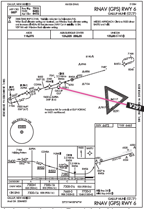
Now, there’s the matter of getting around the Special Use Airspace. That is, if you must. There are two Restricted Areas southeast of Gallup. Yep, two. Don’t be fooled by the single, triangular R-5117 depicted on the en-route chart. Toggle on the airspaces overlay on your EFB (and on some, zoom out to make it appear), or look at the high chart. Another Restricted area, R-5121, appears, adjacent to the east. Tap each one for details: R-5117 is “Surface to Unlimited” while R-5121 is “FL200 to Unlimited.”
This more complete view of the restricted airspaces shows on the high-altitude charts, which start at 18,000 feet, but that’s not evident on many pinch-and-zoom EFBs. Both spaces are hot, so while you can fly beneath the east-side RA, not so for R-5117. Not only that, a circular TFR has joined the fray. It appears to be a daily operation from the surface to 11,000 MSL. Normally overflying is an option, but the overlap with R-5117 prevents that.
That could be a non-issue if continuing on to the RNAV 24 at BLINI: From there head northwest to the IAF/IF BAXTU then straight in to 24, bypassing the SUAs. Plus, using that approach would be coming into Gallup from the east without having to spend the extra time and fuel to go past the airport for an approach to Runway 6, which has a similar LNAV-only procedure. If only the wind would cooperate…
Or This Way
That last bit will determine the final plan. It took a day’s delay for the damp, misty weather to clear out of Texas and dry out the clouds, which at departure time should only reach 2000 feet en route. That provided some time to set up the oxygen and re-pack, but it also allowed the surface winds at Gallup to shift southeast, and it could be anywhere from five to 15 knots at your ETA. You’re willing to land with a five-knot tailwind component, but no more.
In that case, it’ll be the RNAV 6, coming from the south/southwest of KGUP to pick up ZUPRA (IF/IAF) and a hold-in-lieu-of-procedure turn to the final course. You have to figure out how to get to ZUPRA; there’s no direct way from your route because of the SUAs, so prepare for vectors or a healthy re-route.
The RNAV 6 approach also is more complex, with stepdowns continuing beyond the final fix. The LNAV MDA is 7300 feet for Category A and B, both straight in and circling. (This is 60 feet lower than the 24 approach, making either procedure good from that respect.) Missed approach course is runway heading to “9500 direct BAXTU and hold.”
Or, fly the 24 approach via BLINI and BAXTU and circle to the other runway after getting a preview of the field. That’s appealing … the clouds are layered at 1100 feet scattered, 2500 scattered, 7000 broken. That’s good enough to fly a low (500 feet below the clouds), left-hand traffic pattern for a circling approach. Sure beats taking the extra time to reach Gallup from the south, or re-routing off airways. And there’s just one stepdown before the final fix (at/above 8700 feet) then one at or above 7500 feet at DEYEB.
The 24 approach is the shortest way to the airport, easily avoids the TFR and Restricted airspace, and from your filed route avoids the HILPT. Cons: The possible circle-to-land and the climbing-turning missed approach path. These aren’t dealbreakers as the weather is well above minimums, but now you see that numerous obstacles will require another approach comparison.
Fine Print
The obstacles depicted on both approach planviews are tangled up between all the stepdown altitudes, so you’ll want to you pick your way carefully through each chart. Just about every close-in obstacle that is depicted on the approach charts is consistent between the RNAV 6 and 24, except for one. The Runway 6 chart shows one that overlaps with a 6781-foot obstacle, 7039±.
Since that’s located a hair south of the approach course at about a two-mile final, it gets your attention and you chalk one up for the 24 approach. But back to the latter’s climbing-right-turn missed: While you’d expect a go-around to start in VMC and turn well east of the unconfirmed obstacle, the flight path back to BAXTU goes right by (and hopefully above) three more obstacles, reading 6886 feet, 7487 and 7195 (there’s that darn ± again).
The ± symbols, according to the FAA Aeronautical Chart User’s Guide, indicate a given obstacle height is of “doubtful accuracy.” Rounding everything up makes the highest, nearest obstacles more than 1000 feet tall, and naturally bypassing those by some hundreds of feet would be the minimal comfort level. So it’s critical here to fly right on course and no lower than the minimums published. Using the latest airport weather, the RNAV 24 still seems the safer option, but since conditions could shift just enough to make that tailwind an uncomfortable prospect, you hold the RNAV 6 as Plan B. And, limit yourself to two approaches total, even if you don’t switch runways. In essence, any second missed approach means heading to the alternate.
You depart Amarillo on time and treat the trip as two legs: Albuquerque, for fuel and continue/stop decision, then Gallup if it works out today. With winds varying now from the southeast at five knots, you launch for the second leg and find a better speed aloft than expected, so it’s not long before you get pointed towards BLINI and receive the approach clearance for 24. Once at 9500 feet, you see the field before reaching BAXTU. It’s a big hole, but not a completely clear shot until final.
In the two minutes between BAXTU and FESIX, you check the ASOS: 120 degrees, seven knots. Continue, but keep that approach speed right at 80 knots. The gap in the clouds is now clear all the way, but you stay on the needles and ready for a go-around/published missed all the way to touchdown.
Two reasons for this: The tailwind did nudge you just past the first taxiway one-third down the runway. You had just a second to make the continue/reject call before touching down at the second taxiway, which was your hard limit for landing on 24. The early visual conditions were great to have, but it didn’t relieve the workload in the last couple of miles due to the uncertain winds potentially forcing a missed approach and/or runway change. That was the most challenging part—constantly weighing the options in flight, even with all those details planned-out in advance.
Elaine Kauh is a CFII in eastern Wisconsin. Even though she flies with an EFB that displays groundspeed and even cabin altitude, she still geeks out over figuring those with a punch-key calculator.


