
It’s a misty, cool morning in Merrill, Wisconsin and the patchy fog hanging around the airport is common for late summer into early autumn. While you wait for the sun to burn off enough to comfortably depart in your four-cylinder Piper, you’re eyeing conditions en route to Cedar Rapids, Iowa (KCID).
A 5:30 a.m. takeoff isn’t your first choice because of the scud, but it’s about a two-hour minimum flight to KCID and a long workday awaits. You’re getting in a hurry.
Routine Flight
With winds from the east, you’ll expect ILS or RNAV 9 approaches at KCID. However, the 1/4SM FG OVC001 noted on the latest METAR is not looking good for getting in unless it clears up to published minimums of 200 feet for your arrival.
It does cross your mind that while you’ve flown this route several times over the summer, the skies have been either clear or mostly so, allowing for visual approaches. Plus, it’s been about three months since you’ve climbed through more than a scattered layer. Is this a big deal?
Maybe. You had been filing direct without bothering to check on procedures. You also hadn’t bothered to file an alternate in quite a while, since it wasn’t required.
But now, you need to do some homework. The forecast at Cedar Rapids calls for the visibility to creep up to 1 1/2SM at your ETA, with mist and a broken ceiling at 300 feet, allowing for a precision approach.
Are you up for this after a few months of visual approaches? You’re current, comfortable with the aircraft, and familiar with the airport, so you don’t see any problems. Besides, it’s time to launch and that low stuff is sure to start burning off by the time you get there as “P6SM and “SCT015” are forecast an hour after your arrival. In fact, you don’t even need to look for an alternate now to meet 14 CFR 91.169 (b)(2) as the ceiling and visibility are expected to be better than 2000 feet and 3 SM at that time.
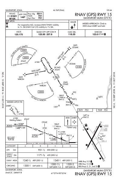
Still, you consider filing your usual backup, Iowa City just to the southeast. It’s a tad worse than CID, currently 1/4 mile and 100 feet there. Will it be a legal alternate under 91.169(c) and get to at least 600-2 by 8 a.m.? Relying on the Cedar Rapids TAF, it’s supposed to be above that. You also check further east and see Muscatine and Davenport, Iowa, and Moline, Illinois. Using the Moline TAF, things ought to be well above the “alternate airport weather minima” by your ETA as required by the regs. Davenport offers two good precision approaches, less taxi time and a simpler drive to Cedar Rapids. Not that you’re actually expecting it to come to that. So you pop in Davenport for the alternate.
A Good Plan?
Ready now? Not quite. You’ve had to file an alternate, which just messed up your fuel strategy—departing with what had been sitting in the tanks for three weeks ’cause you weren’t planning on any of this. So what do you need to get to Cedar Rapids along with reserves required under 91.167? You’ll fly two hours to the airport, which for the Piper means 18 gallons. Add five or so (just to be safe) to fly an approach, plus another five to do the same at the alternate. That’s 28 gallons plus 45 minutes’ worth to meet the regs for a reserve. Is there enough? Both tanks are at the tabs—well, nearly—so you must be good to go, and go right now.
Once stable in cruise at 8000 feet, you check the destination weather. It’s 100-1/2. There seems to be a good amount of ground showing, but there are also plenty of patchy low layers, albeit just a couple hundred feet thick. You press on and get a clearance to VINTY then FEMIT for the RNAV to Runway 9. The LPV approach wants 200 and 1/2 mile. For you, pressing on is certainly legal. You can fly the approach in any weather and just need the minimum vis to land under 91.175(c)(2).
Two misses and about a half hour later, you’re cleared to Davenport. So much for being on time, which you obviously wasted trying to get in (twice). What’s the quickest way to KDVN? Go direct WIRON, which is just a few miles in front of you and right on the RNAV 15 approach. Now for the weather. The ASOS reports a touch better, a mile and broken at 100 feet. Davenport is by no means a required diversion just ’cause you filed it. The issue is you just don’t have reserves to stay aloft shopping around for a new destination. So what about Iowa City? Cedar Rapids? Anything back the other way? Now you wish you had more fuel.
The Real Alternate
Looking just south of you through the gaps in the scud, you see an airport. It’s one runway and looks awfully small. What are your other options? With WIRON close, do you continue with that weather? Or, do you use more fuel to go somewhere otherwise more comfortable? Do you head west to unfamiliar airports that you had never checked on? For the first time ever you use the “nearest” feature on the GPS.
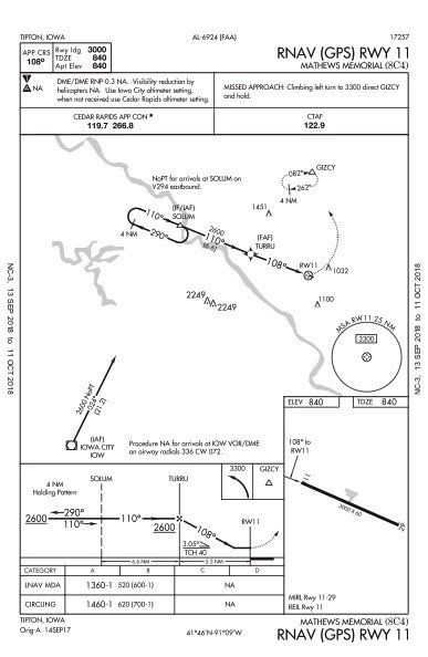
Turns out you’re over Mathews Memorial (8C4) in Tipton, Iowa, a 3000-foot strip not quite halfway between Cedar Rapids and Davenport. Now you’ve got to think fast again. Can you stay in VMC and get down, or do you need to get cleared there and use at least part of the RNAV approach to Runway 11?
The LNAV-only approach goes to 520 feet. This is the only procedure available other than a VOR 11 approach. No way are you doing that. It occurs to you that at this point, you’d rather be in VMC now with some fuel margin than in IMC using it all up. You can always keep talking to Cedar Rapids Approach if you need help. When it’s clear, just fly a VFR beeline to a fuel stop. It’s settled. You get on the ground at Tipton and suddenly, being late for work doesn’t seem so important now.
Every flight is at the mercy of the weather, forecast or otherwise. Whether you’ve meticulously laid out a well-briefed plan or rushed out the door with a glance at the chart, unplanned diversions can and do happen. Regulations notwithstanding, it pays to take the time to get the whole picture, especially when it comes to alternates. Those options aren’t always chosen, obvious or even desirable, but they can be the safest.
Elaine Kauh is a CFII in eastern Wisconsin. She always looks forward to flying along the Mississippi to take in the exotic landscapes of Illinois and Iowa.


